IMAGES TAKEN NEAR TO
Loftus Grove, NEWPORT, NP19 0PH
Introduction
This page details the photographs taken nearby to Loftus Grove, NP19 0PH by members of the Geograph project.
The Geograph project started in 2005 with the aim of publishing, organising and preserving representative images for every square kilometre of Great Britain, Ireland and the Isle of Man.

There are currently over 7.5m images from over14,400 individuals and you can help contribute to the project by visiting https://www.geograph.org.uk
Image Map
Images are licensed for reuse under creativecommons.org/licenses/by-sa/2.0
Notes
- Clicking on the map will re-center to the selected point.
- The higher the marker number, the further away the image location is from the centre of the postcode.
Image Listing (199 Images Found)
Images are licensed for reuse under creativecommons.org/licenses/by-sa/2.0
Image
Details
Distance
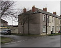
1
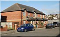
Redvers Street modern housing, Newport
Housing at the far end of Redvers Street.
Image: © Jaggery
Taken: 28 Jan 2010
0.01 miles
2
Ludlow Close, Newport
Viewed from Lilburne Drive.
Image: © Jaggery
Taken: 28 Jan 2010
0.05 miles
3
North along Hathaway Street, Newport
From Dewstow Street, Hathaway Street leads to Loftus Grove and Loftus Garden Village.
Image: © Jaggery
Taken: 21 Feb 2020
0.06 miles
4
East along Dewstow Street, Newport
Looking past the corner of Hathaway Street towards the distant left turn for Redvers Street.
Image: © Jaggery
Taken: 5 May 2014
0.07 miles
5
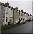
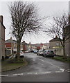
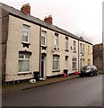
Row of houses, Dewstow Street, Newport
Extending for 55 metres from Hathaway Street to Redvers Street.
Image: © Jaggery
Taken: 21 Feb 2020
0.07 miles
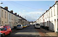
6
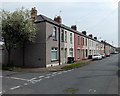
Redvers Street, Newport
Houses on the west side of Redvers Street, viewed from near the corner of Dewstow Street.
Image: © Jaggery
Taken: 28 Jan 2010
0.07 miles
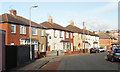
7
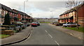
Dewstow Street, Newport
Looking west along Dewstow Street from the corner of Keene Street.
Image: © Jaggery
Taken: 28 Jan 2010
0.07 miles
8
Corner of Dewstow Street and Hathaway Street, Newport
The trees are in Hathaway Street. https://www.geograph.org.uk/photo/6396937
Image: © Jaggery
Taken: 21 Feb 2020
0.08 miles
9
Row of houses on the north side of Dewstow Street, Newport
Originally part of a longer row. Three houses formerly beyond the left
edge of the photo were destroyed by Luftwaffe bombing in August 1940.
The bombsite remains fenced off in February 2020. https://www.geograph.org.uk/photo/6396920
Image: © Jaggery
Taken: 21 Feb 2020
0.08 miles
10
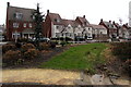
Loftus Avenue houses, Newport
Houses in Loftus Garden Village built in the second decade of the 21st century.
Image: © Jaggery
Taken: 21 Feb 2020
0.08 miles