IMAGES TAKEN NEAR TO
Liberty Grove, NEWPORT, NP19 0ND
Introduction
This page details the photographs taken nearby to Liberty Grove, NP19 0ND by members of the Geograph project.
The Geograph project started in 2005 with the aim of publishing, organising and preserving representative images for every square kilometre of Great Britain, Ireland and the Isle of Man.

There are currently over 7.5m images from over14,400 individuals and you can help contribute to the project by visiting https://www.geograph.org.uk
Image Map
Images are licensed for reuse under creativecommons.org/licenses/by-sa/2.0
Notes
- Clicking on the map will re-center to the selected point.
- The higher the marker number, the further away the image location is from the centre of the postcode.
Image Listing (185 Images Found)
Images are licensed for reuse under creativecommons.org/licenses/by-sa/2.0
Image
Details
Distance
1
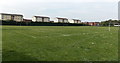
Football pitches in Lysaghts Park, Newport
Viewed from the Corporation Road side looking towards houses in Liberty Grove.
Image: © Jaggery
Taken: 5 May 2014
0.02 miles
2
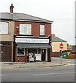
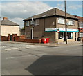
Daisy Chain Florist, Newport
At 333 Corporation Road, on the corner of Dewstow Street.
Image: © Jaggery
Taken: 23 Sep 2009
0.05 miles
3
Thomas & Strong Ltd, Corporation Road, Newport
Janitorial supplies, located at 408 Corporation Road.
Image: © Jaggery
Taken: 24 Dec 2009
0.05 miles
4
Faber & Smith Ltd, Corporation Road, Newport
Architectural ironmongers, carpentry and building supplies.
Image: © Jaggery
Taken: 24 Dec 2009
0.05 miles
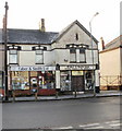
5
L.T. Chemists, Corporation Road, Newport
Pharmacy (dispensing chemists) at 335 Corporation Road, on the corner of Dewstow Street.
'Numark', previously prominently displayed on both name boards, is now reduced to a hardly noticeable small size at the lower right corner of the boards.
Image: © Jaggery
Taken: 5 Aug 2011
0.05 miles
6
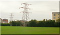
Pylon, Lysaghts Park, Newport
Viewed from Corporation Road. The pylon is in the southeast corner of Lysaghts Park, adjacent to Portskewett Street.
Image: © Jaggery
Taken: 23 Sep 2009
0.07 miles
7
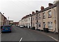
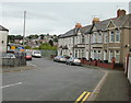
Lilleshall Street, Newport
Viewed from the Corporation Road end looking towards newer houses in Liberty Grove and Seabreeze Avenue.
Image: © Jaggery
Taken: 5 May 2014
0.07 miles
8
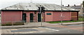
Lysaghts Park Public Toilets, Newport
On Corporation Road, opposite Walsall Street and Wednesbury Street.
Image: © Jaggery
Taken: 23 Sep 2009
0.07 miles
9
Wednesbury Street, Newport
Viewed from Corporation Road.
Image: © Jaggery
Taken: 23 Sep 2009
0.07 miles
10

Corporation Road Baptist Church, Newport
Opened in 1898 ; rebuilt in the 1960s. Located on the corner of Corporation Road and Wednesbury Street.
Image: © Jaggery
Taken: 23 Sep 2009
0.07 miles