1
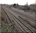
Somerton railway junction, Newport
The view east from Somerton Road bridge. On the right, a single track line heads away from the 4-track South Wales main line. The single track bends through 90 degrees ahead, to follow a route to the SW and S to industrial areas adjacent to the River Usk, Newport Docks and Uskmouth Power Station.
Image: © Jaggery
Taken: 15 Dec 2010
0.02 miles
2
View from a Bristol-Cardiff train - East Usk Junction
A short freight branch to the right, runs along the east side of the River Usk.
Image: © Nigel Thompson
Taken: 14 Aug 2015
0.03 miles
3
Libeneth Road houses, Newport
Houses on the south side of Libeneth Road, close to the roundabout http://www.geograph.org.uk/photo/1683011 at the corner of Hawthorn Avenue.
Image: © Jaggery
Taken: 28 Jan 2010
0.05 miles
4
Libeneth Road, Newport
Libeneth Road climbs away from the corner of Hawthorn Avenue. http://www.geograph.org.uk/photo/1683011
Image: © Jaggery
Taken: 28 Jan 2010
0.05 miles
5
Laburnum Drive, Newport
Houses on the east side of the southern end of Laburnum Drive, viewed from Libeneth Road.
Image: © Jaggery
Taken: 28 Jan 2010
0.05 miles
6
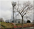
Mobile phone mast, Libeneth Road, Newport
The mast is located on the highest point on Libeneth Road. Most of Newport to the south of this point is flat land, unlike the very hilly terrain in most of the northern part of the city.
Image: © Jaggery
Taken: 28 Jan 2010
0.05 miles
7
London train passes Somerton
Image: © Roger Cornfoot
Taken: 3 May 2007
0.05 miles
8
Somerton railway junction, Newport
Viewed from Somerton Road bridge. On the left are the four tracks of the South Wales main line.
On the right side of the main line is an industrial branch line, where a diesel locomotive hauling a freight train waits at signals.
Image: © Jaggery
Taken: 5 Jan 2013
0.06 miles
9
On-street and on-pavement parking, Camperdown Road, Newport
Dead-end road on the northeast side of Somerton Road.
Image: © Jaggery
Taken: 5 Mar 2020
0.07 miles
10
Collingwood Road, Newport
Viewed from the Somerton Road end.
Image: © Jaggery
Taken: 20 Nov 2009
0.07 miles


