IMAGES TAKEN NEAR TO
Collingwood Avenue, NEWPORT, NP19 0JS
Introduction
This page details the photographs taken nearby to Collingwood Avenue, NP19 0JS by members of the Geograph project.
The Geograph project started in 2005 with the aim of publishing, organising and preserving representative images for every square kilometre of Great Britain, Ireland and the Isle of Man.

There are currently over 7.5m images from over14,400 individuals and you can help contribute to the project by visiting https://www.geograph.org.uk
Image Map
Images are licensed for reuse under creativecommons.org/licenses/by-sa/2.0
Notes
- Clicking on the map will re-center to the selected point.
- The higher the marker number, the further away the image location is from the centre of the postcode.
Image Listing (203 Images Found)
Images are licensed for reuse under creativecommons.org/licenses/by-sa/2.0
Image
Details
Distance
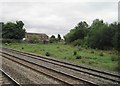
1
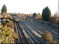
Somerton railway junction, Newport
The view east from Somerton Road bridge. On the right, a single track line heads away from the 4-track South Wales main line. The single track bends through 90 degrees ahead, to follow a route to the SW and S to industrial areas adjacent to the River Usk, Newport Docks and Uskmouth Power Station.
Image: © Jaggery
Taken: 15 Dec 2010
0.02 miles
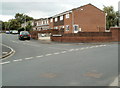
2
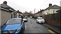
On-street and on-pavement parking, Camperdown Road, Newport
Dead-end road on the northeast side of Somerton Road.
Image: © Jaggery
Taken: 5 Mar 2020
0.04 miles
3
Camperdown Road, Newport
Viewed from the Somerton Road end. The single-storey building on the left is Lliswerry Baptist Church. http://www.geograph.org.uk/photo/1588979
Image: © Jaggery
Taken: 20 Nov 2009
0.05 miles
4
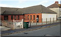
Lliswerry Baptist Church, Newport
Located on Camperdown Road.
Image: © Jaggery
Taken: 20 Nov 2009
0.05 miles
5
Camperdown House, Newport
Located at the far end of Camperdown Road, on the other side of the street from Lliswerry Baptist Church. http://www.geograph.org.uk/photo/1588979
Camperdown House is owned by the fellowship of Lliswerry Baptist Church.
It uses (current or planned) :
1) for the community as a drop-in centre, an open house for coffee etc.
2) a manned office.
3) a youth centre.
4) a place for additional facilities for church work.
5) a resource centre providing helpful material for the public and church.
6) counselling facilities (with trained counsellors) and a training centre for young people to develop IT, writing and communication skills.
Image: © Jaggery
Taken: 20 Nov 2009
0.05 miles
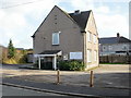
6
Far end of Collingwood Avenue, Newport
Collingwood Avenue is a cul-de-sac of houses and flats built in the early 1980s.
Image: © Jaggery
Taken: 15 Dec 2010
0.05 miles
7
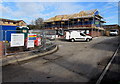
Frobisher Gardens house construction site, Newport
In February 2016, sixteen two- and three-bedroom houses are being built
on former waste ground between Frobisher Road and the South Wales main line railway.
Image: © Jaggery
Taken: 16 Feb 2016
0.05 miles
8
View from a Bristol-Cardiff train - East Usk Junction
A short freight branch to the right, runs along the east side of the River Usk.
Image: © Nigel Thompson
Taken: 14 Aug 2015
0.06 miles
9
Hawksworth Grove, Newport
Houses on the east side of the street, viewed from Churchward Drive. Three adjacent roads in this area are named after Chief Mechanical Engineers (CME) of the Great Western Railway (GWR). The two in view here were named after:
Frederick Hawksworth (1884-1976) was CME from 1941. He was the last CME of the GWR, which became part of the nationalised British Railways in 1948.
George Jackson Churchward (1857-1933) was CME of the GWR from 1902 to 1922.
Fittingly, the three roads are adjacent to railway lines.
See http://www.geograph.org.uk/photo/2549492 for details of the third GWR man, Armstrong.
Image: © Jaggery
Taken: 10 Aug 2011
0.07 miles
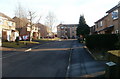
10
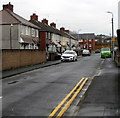
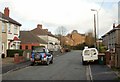
Frobisher Road, Newport
From Somerton Road along Frobisher Road towards the Blake Road junction.
Image: © Jaggery
Taken: 5 Mar 2020
0.07 miles