IMAGES TAKEN NEAR TO
Barthropp Street, NEWPORT, NP19 0JQ
Introduction
This page details the photographs taken nearby to Barthropp Street, NP19 0JQ by members of the Geograph project.
The Geograph project started in 2005 with the aim of publishing, organising and preserving representative images for every square kilometre of Great Britain, Ireland and the Isle of Man.

There are currently over 7.5m images from over14,400 individuals and you can help contribute to the project by visiting https://www.geograph.org.uk
Image Map
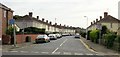
Images are licensed for reuse under creativecommons.org/licenses/by-sa/2.0
Notes
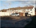
- Clicking on the map will re-center to the selected point.
- The higher the marker number, the further away the image location is from the centre of the postcode.
Image Listing (180 Images Found)
Images are licensed for reuse under creativecommons.org/licenses/by-sa/2.0
Image
Details
Distance
1
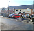
Modern housing, Lloyd Street, Newport
Recently-built housing on the west side of Lloyd Street on a site previously occupied by business premises.
Image: © Jaggery
Taken: 15 Dec 2010
0.03 miles
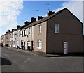
2
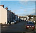
Older housing, Lloyd Street, Newport
The view north past older terraced housing on Lloyd Street, from the edge of modern housing. http://www.geograph.org.uk/photo/2199183
Image: © Jaggery
Taken: 15 Dec 2010
0.03 miles
3
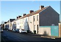
Ifton Street, Newport
Houses on the north side of Ifton Street, viewed from the corner of Lloyd Street.
Image: © Jaggery
Taken: 15 Dec 2010
0.03 miles
4
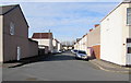
Ifton Street, Newport
West along Ifton Street from Lloyd Street towards Barthropp Street and Ifton Place.
Image: © Jaggery
Taken: 16 Feb 2016
0.06 miles
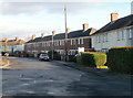
5
Lloyd Street houses, Newport
The corner of Ifton Street is on the right.
Image: © Jaggery
Taken: 16 Feb 2016
0.06 miles
6
Lloyd Street, Newport
From Somerton Road, Lloyd Street leads to Ifton Street.
Image: © Jaggery
Taken: 5 Mar 2020
0.06 miles
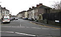
7
Southern end of Hampden Road, Newport
Houses on the east side of Hampden Road, viewed from the V-shaped bend connecting the road with Oliver Road. http://www.geograph.org.uk/photo/2198435
Image: © Jaggery
Taken: 15 Dec 2010
0.07 miles
8
Hampden Court, Newport
Hampden Court is a small cul-de-sac connecting with Hampden Road. http://www.geograph.org.uk/photo/2198423
Image: © Jaggery
Taken: 15 Dec 2010
0.07 miles
9
Colston Court, Newport
Colston Court is a cul-de-sac of 12 houses at the SE end of Colston Place. This is one of two groups of 6 houses.
Image: © Jaggery
Taken: 15 Dec 2010
0.07 miles
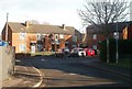
10
Hampden Road, Newport
Viewed from near the Cromwell Road end.
Image: © Jaggery
Taken: 24 Sep 2009
0.07 miles