IMAGES TAKEN NEAR TO
Somerton Road, NEWPORT, NP19 0JE
Introduction
This page details the photographs taken nearby to Somerton Road, NP19 0JE by members of the Geograph project.
The Geograph project started in 2005 with the aim of publishing, organising and preserving representative images for every square kilometre of Great Britain, Ireland and the Isle of Man.

There are currently over 7.5m images from over14,400 individuals and you can help contribute to the project by visiting https://www.geograph.org.uk
Image Map
Images are licensed for reuse under creativecommons.org/licenses/by-sa/2.0
Notes
- Clicking on the map will re-center to the selected point.
- The higher the marker number, the further away the image location is from the centre of the postcode.
Image Listing (202 Images Found)
Images are licensed for reuse under creativecommons.org/licenses/by-sa/2.0
Image
Details
Distance
1
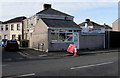
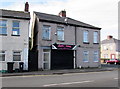
K Seto takeaway, Newport
Chinese food and fish & chips takeaway at 64 Somerton Road, on the corner of Downing Street.
In February 2016, a white-on-red temporary sign shows that Somerton Road railway bridge is closed.
It is being rebuilt as part of the South Wales railway electrification project.
Image: © Jaggery
Taken: 16 Feb 2016
0.00 miles
2
K. Seto Chinese takeaway, 64 Somerton Road, Newport
The Chinese takeaway on the corner of Downing Street also sells fish & chips.
Image: © Jaggery
Taken: 5 Mar 2020
0.00 miles
3
Somerton rail bridge closed sign, Somerton Road, Newport
In February 2016, a temporary sign on the corner of Downing Street and Somerton Road shows that Somerton Road railway bridge is closed. It is being rebuilt as part of the South Wales railway electrification project.
Image: © Jaggery
Taken: 16 Feb 2016
0.00 miles
4
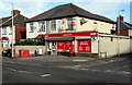
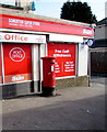
Somerton Super Store and Lliswerry Post Office, Newport
Viewed in mid February 2016. The shop on the corner of Somerton Road and Camperdown Road has gained a post office & pillarbox http://www.geograph.org.uk/photo/4829761 and had a makeover since this http://www.geograph.org.uk/photo/1962301 2009 photo. There seems to be some confusion as to where this shop is, in the sense that Somerton and Liswerry (sometimes spelt Lliswerry) are different areas of Newport, though their boundaries are not exactly defined on maps I've consulted.
Image: © Jaggery
Taken: 16 Feb 2016
0.01 miles
5
Queen Elizabeth II pillarbox outside Lliswerry Post Office, Newport
Located here. http://www.geograph.org.uk/photo/4829754
Image: © Jaggery
Taken: 16 Feb 2016
0.01 miles
6
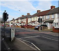
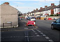
Pelican crossing, Somerton Road, Newport
Across Somerton Road between Camperdown Road and Lloyd Street.
Chambers Dictionary states that "pelican" is adapted from "pedestrian light controlled crossing".
Image: © Jaggery
Taken: 16 Feb 2016
0.01 miles
7
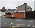
Shaz Snax, Newport
Sandwich bar at 68 Somerton Road, near the corner of Downing Street.
Image: © Jaggery
Taken: 16 Feb 2016
0.02 miles
8

Snacks To Go, 68 Somerton Road, Newport
Takeaway near the corner of Downing Street.
Image: © Jaggery
Taken: 5 Mar 2020
0.02 miles
9
Somerton Road pelican crossing, Newport
Near the Lloyd Street junction ahead on the left. Chambers Dictionary states
that pelican is this context is adapted from "pedestrian light controlled crossing".
Image: © Jaggery
Taken: 5 Mar 2020
0.02 miles
10
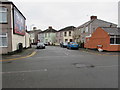
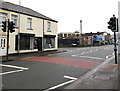
Towards a bend in Downing Street, Newport
Dead-end Downing Street viewed across Somerton Road in March 2020.
Image: © Jaggery
Taken: 5 Mar 2020
0.02 miles