IMAGES TAKEN NEAR TO
Milner Street, NEWPORT, NP19 0GS
Introduction
This page details the photographs taken nearby to Milner Street, NP19 0GS by members of the Geograph project.
The Geograph project started in 2005 with the aim of publishing, organising and preserving representative images for every square kilometre of Great Britain, Ireland and the Isle of Man.

There are currently over 7.5m images from over14,400 individuals and you can help contribute to the project by visiting https://www.geograph.org.uk
Image Map
Images are licensed for reuse under creativecommons.org/licenses/by-sa/2.0
Notes
- Clicking on the map will re-center to the selected point.
- The higher the marker number, the further away the image location is from the centre of the postcode.
Image Listing (153 Images Found)
Images are licensed for reuse under creativecommons.org/licenses/by-sa/2.0
Image
Details
Distance
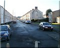
1
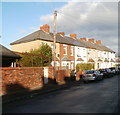
Odd numbers, Milner Street, Newport
This row of houses at the far end of Milner Street contains 7 houses, numbered 1-13. Originally, these were the only houses on this (the west) side of the street. Three houses http://www.geograph.org.uk/photo/2198391 were then built, decades later, just around the corner.
The rest of this side is occupied by school buildings (St Andrew's Junior School and St Andrew's Infants School and Nursery http://www.geograph.org.uk/photo/2198286)
The houses on the other (even numbered) side of the street are numbered 2-48.
Image: © Jaggery
Taken: 15 Dec 2010
0.02 miles
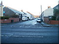
2

Newer houses at the far end of Milner Street, Newport
Originally, the only houses on the west side of Milner Street were those in a row http://www.geograph.org.uk/photo/2198294 at the far end of the street. Decades later, the three houses seen here were built, set back a few metres from the end of the row, behind a row of lock-up garages.
Image: © Jaggery
Taken: 15 Dec 2010
0.02 miles
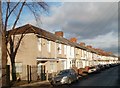
3
Magor Street, Newport
Viewed across Corporation Road. Magor Street is a long cul-de-sac of mostly terraced houses, dating from about 1920. There are some much more recently-built maisonettes http://www.geograph.org.uk/photo/2198413 at the far end of the street.
Image: © Jaggery
Taken: 5 Dec 2010
0.04 miles
4
West side of Hamilton Street, Newport, viewed from the south
Viewed from near the junction with Corporation Road. The tree is at the edge of a library site. http://www.geograph.org.uk/photo/1621495
http://www.geograph.org.uk/photo/2198401 to the view of this side of the street from the far end.
Image: © Jaggery
Taken: 15 Dec 2010
0.04 miles
5
Hamilton Street, Newport
Viewed from opposite a library http://www.geograph.org.uk/photo/1621495 at the corner of Corporation Road. Hamilton Street extends to the edge of a recreation ground.
Image: © Jaggery
Taken: 15 Dec 2010
0.04 miles
6
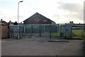
The Mary Dunn Club, Newport
Located in the north east corner of a recreation ground, accessed from Jenkins Street.
Image: © Jaggery
Taken: 28 Jan 2010
0.06 miles
7
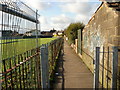
Path along the edge of a recreation ground adjacent to Jenkins Street, Newport
Looking along the path which skirts the northern edge of a recreation ground, viewed from the corner of Jenkins Street and the entrance to the Mary Dunn Club. http://www.geograph.org.uk/photo/1681865
Image: © Jaggery
Taken: 28 Jan 2010
0.06 miles
8
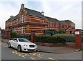
Milner Street side of St Andrew's Junior School, Newport
The buildings are Edwardian, dating from 1902 when the school opened as Corporation Road Board School.
Image: © Jaggery
Taken: 5 May 2014
0.06 miles
9
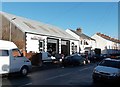
Autobest, Magor Street, Newport
Garage providing vehicle repairs, servicing and welding,
located in Magor Street near the Corporation Road junction.
Image: © Jaggery
Taken: 11 Jan 2013
0.07 miles
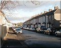
10
Newport : Magor Street viewed from the far end
Looking towards Corporation Road from the far end of the street. Formerly, there was vehicular access into Oliver Road, but this has been blocked off.
On the right are maisonettes, http://www.geograph.org.uk/photo/2198413 built many decades after the rest of the street. The appearance of the end of the terrace suggests that some terraced housing was demolished to make way for the maisonettes.
Image: © Jaggery
Taken: 15 Dec 2010
0.07 miles