IMAGES TAKEN NEAR TO
Dewstow Street, NEWPORT, NP19 0FT
Introduction
This page details the photographs taken nearby to Dewstow Street, NP19 0FT by members of the Geograph project.
The Geograph project started in 2005 with the aim of publishing, organising and preserving representative images for every square kilometre of Great Britain, Ireland and the Isle of Man.

There are currently over 7.5m images from over14,400 individuals and you can help contribute to the project by visiting https://www.geograph.org.uk
Image Map
Images are licensed for reuse under creativecommons.org/licenses/by-sa/2.0
Notes
- Clicking on the map will re-center to the selected point.
- The higher the marker number, the further away the image location is from the centre of the postcode.
Image Listing (170 Images Found)
Images are licensed for reuse under creativecommons.org/licenses/by-sa/2.0
Image
Details
Distance
1
Keene Street, Newport
Looking north along Keene Street from the Cromwell Road end towards Hammond Drive.
Image: © Jaggery
Taken: 28 Jan 2010
0.02 miles
2
Hammond Drive from the east, Newport
Looking along the north side of Hammond Drive, from Lilburne Drive.
Image: © Jaggery
Taken: 28 Jan 2010
0.02 miles
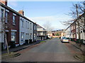
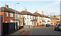
3
East along Dewstow Street, Newport
Looking past the corner of Hathaway Street towards the distant left turn for Redvers Street.
Image: © Jaggery
Taken: 5 May 2014
0.03 miles
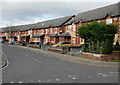
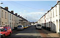
4
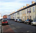
Row of houses, Dewstow Street, Newport
Extending for 55 metres from Hathaway Street to Redvers Street.
Image: © Jaggery
Taken: 21 Feb 2020
0.03 miles
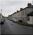
5
Redvers Street, Newport
Houses on the west side of Redvers Street, viewed from near the corner of Dewstow Street.
Image: © Jaggery
Taken: 28 Jan 2010
0.05 miles
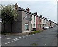
6
Dewstow Street, Newport
Looking west along Dewstow Street from the corner of Keene Street.
Image: © Jaggery
Taken: 28 Jan 2010
0.05 miles
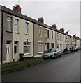
7
East along Dewstow Street, Newport
Towards Keene Street. The broken white line is at the Caldicot Street junction.
Image: © Jaggery
Taken: 21 Feb 2020
0.05 miles
8
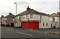
Cromwell Stores, Newport
Shop and off-licence on the corner of Cromwell Road and Keene Street.
The shop was formerly named Greenleaf Stores. http://www.geograph.org.uk/photo/1682058
Image: © Jaggery
Taken: 5 Jan 2013
0.05 miles
9
Oakley Street, Newport
Houses on the southeast side of Oakley Street, viewed from near the Slade Street junction, looking towards Cromwell Road.
Image: © Jaggery
Taken: 28 Jan 2010
0.06 miles
10
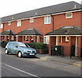
St Philip's Flats, Cromwell Road, Newport
Adjacent to the Oakley Street junction.
Image: © Jaggery
Taken: 28 Jan 2010
0.06 miles