IMAGES TAKEN NEAR TO
Wednesbury Street, NEWPORT, NP19 0EZ
Introduction
This page details the photographs taken nearby to Wednesbury Street, NP19 0EZ by members of the Geograph project.
The Geograph project started in 2005 with the aim of publishing, organising and preserving representative images for every square kilometre of Great Britain, Ireland and the Isle of Man.

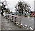
There are currently over 7.5m images from over14,400 individuals and you can help contribute to the project by visiting https://www.geograph.org.uk
Image Map
Images are licensed for reuse under creativecommons.org/licenses/by-sa/2.0
Notes
- Clicking on the map will re-center to the selected point.
- The higher the marker number, the further away the image location is from the centre of the postcode.
Image Listing (211 Images Found)
Images are licensed for reuse under creativecommons.org/licenses/by-sa/2.0
Image
Details
Distance
1
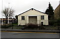
Wednesbury Street side of Corporation Road Baptist Church, Newport
The southeast side of this https://www.geograph.org.uk/photo/1620946 church.
Image: © Jaggery
Taken: 21 Feb 2020
0.01 miles
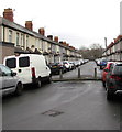
2
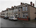
Wednesbury Street houses, Newport
Row of houses on the east side of Wednesbury Street. Corporation Road is behind the camera.
Image: © Jaggery
Taken: 21 Feb 2020
0.02 miles
3
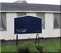
Information board outside Corporation Road Baptist Church, Newport
Faded in February 2020, the board on the left here https://www.geograph.org.uk/photo/1620946 shows that Sunday Service begins at 11am.
Image: © Jaggery
Taken: 21 Feb 2020
0.02 miles
4
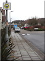
Neighbourhood Watch Area notice, Wednesbury Street, Newport
On the approach to the Loftus Crescent junction.
Image: © Jaggery
Taken: 21 Feb 2020
0.03 miles
5
Pelican crossing opposite Lysaghts Park, Newport
Viewed across Corporation Road. Chambers Dictionary states that pelican in this context is adapted from pedestrian light controlled crossing.
Image: © Jaggery
Taken: 21 Feb 2020
0.03 miles
6
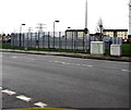
Two grey cabinets at the edge of Lysaghts Park, Newport
Viewed across Corporation Road from the corner of Wednesbury Street.
Image: © Jaggery
Taken: 21 Feb 2020
0.03 miles
7
Concrete posts across Walsall Street, Newport
Near the southern end of the street. Corporation Road is behind the camera. Telford Street is in the background.
Image: © Jaggery
Taken: 21 Feb 2020
0.03 miles
8
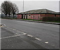
Inconvenient in Lysaghts Park, Newport
Former public toilets viewed across Corporation Road in February 2020.
Image: © Jaggery
Taken: 21 Feb 2020
0.03 miles
9
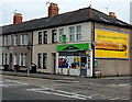
Apex, 291 Corporation Road, Newport
The shop on the corner of Walsall Street was an Apex in early May 2014.
It was Non Stop Booze Bargain http://www.geograph.org.uk/photo/1646756 in January 2010 and later Sovereign Stores.
Image: © Jaggery
Taken: 5 May 2014
0.04 miles
10
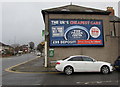
The Trade Centre Wales advert on a Walsall Street wall, Newport
On display on the corner of Corporation Road in February 2020.
Image: © Jaggery
Taken: 21 Feb 2020
0.04 miles