IMAGES TAKEN NEAR TO
Telford Street, NEWPORT, NP19 0ES
Introduction
This page details the photographs taken nearby to Telford Street, NP19 0ES by members of the Geograph project.
The Geograph project started in 2005 with the aim of publishing, organising and preserving representative images for every square kilometre of Great Britain, Ireland and the Isle of Man.

There are currently over 7.5m images from over14,400 individuals and you can help contribute to the project by visiting https://www.geograph.org.uk
Image Map
Images are licensed for reuse under creativecommons.org/licenses/by-sa/2.0
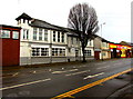
Notes
- Clicking on the map will re-center to the selected point.
- The higher the marker number, the further away the image location is from the centre of the postcode.
Image Listing (237 Images Found)
Images are licensed for reuse under creativecommons.org/licenses/by-sa/2.0
Image
Details
Distance
1
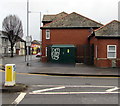
Dark green cabinet, Telford Street, Newport
The cabinet on the corner of Corporation Road is a Western Power Distribution electricity substation. Its identifier is KELVEDON STREET S/S 53-2248. Kelvedon Street is nearby, on the opposite side of Corporation Road.
Image: © Jaggery
Taken: 21 Feb 2020
0.01 miles
2
1-17 Telford Street, Newport
Set back from the west side of the main route of Telford Street.
A sign between the cars shows TELFORD STREET NOS. 1-17
Image: © Jaggery
Taken: 21 Feb 2020
0.01 miles
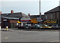
3
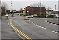
Junction at the southern end of Telford Street, Newport
Looking towards traffic lights at the Corporation Road junction. Ahead for Willenhall Street.
Image: © Jaggery
Taken: 21 Feb 2020
0.01 miles
4
Direction signs at the southern end of Telford Street, Newport
On the corner of Corporation Road. Left along Telford Street for the Council Depot https://www.geograph.org.uk/photo/6395763 and Phoenix Park Industrial Estate. The text is also in Welsh.
Image: © Jaggery
Taken: 21 Feb 2020
0.02 miles
5
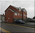
Telford Court, Newport
Telford Street flats near Corporation Road.
Image: © Jaggery
Taken: 21 Feb 2020
0.02 miles
6
Pure Vans premises, Telford Street, Newport
Viewed from the corner of Corporation Road in February 2020.
Image: © Jaggery
Taken: 21 Feb 2020
0.02 miles
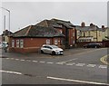
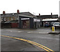
7
Motorcrest and Philip Motors, Telford Street, Newport
Located on the corner of Telford Street and Corporation Road are Motorcrest car sales on the right and Philip Motors (servicing, tyres, MOT, repairs) on the left.
Image: © Jaggery
Taken: 5 May 2014
0.02 miles
8
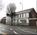
Iqra Masjid & Community Centre, 276 Corporation Road, Newport
Viewed in February 2020. The New Lysaght Club https://www.geograph.org.uk/photo/1620860 was here in 2009.
Image: © Jaggery
Taken: 21 Feb 2020
0.02 miles
9
Iqra Masjid & Community Centre, Newport
Viewed across Corporation Road in February 2020.
The New Lysaght Club https://www.geograph.org.uk/photo/1620860 was here in 2009.
Image: © Jaggery
Taken: 21 Feb 2020
0.03 miles
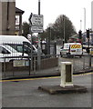
10
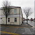
Vivian Road name signs, Newport
On the corner of Corporation Road, a partly rusty old Vivian Road
name sign is on the wall above a newer Vivian Road name sign.
Image: © Jaggery
Taken: 21 Feb 2020
0.03 miles