IMAGES TAKEN NEAR TO
Excelsior Close, NEWPORT, NP19 0DG
Introduction
This page details the photographs taken nearby to Excelsior Close, NP19 0DG by members of the Geograph project.
The Geograph project started in 2005 with the aim of publishing, organising and preserving representative images for every square kilometre of Great Britain, Ireland and the Isle of Man.

There are currently over 7.5m images from over14,400 individuals and you can help contribute to the project by visiting https://www.geograph.org.uk
Image Map
Images are licensed for reuse under creativecommons.org/licenses/by-sa/2.0
Notes
- Clicking on the map will re-center to the selected point.
- The higher the marker number, the further away the image location is from the centre of the postcode.
Image Listing (220 Images Found)
Images are licensed for reuse under creativecommons.org/licenses/by-sa/2.0
Image
Details
Distance
1
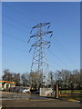
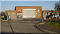
Pylon, Lilleshall Street, Newport
A pylon dominates the eastern edge of Newport City Council's The Bridge training centre. http://www.geograph.org.uk/photo/1658886
Image: © Jaggery
Taken: 4 Jan 2010
0.02 miles
2
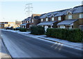
Houses on Willenhall Street, Newport
Part of the Great Western Wharf housing development.
That's not a dusting of snow on surfaces, but hoar frost remaining in shaded areas after a dawn air temperature of minus 7 Celsius, and an air temperature about zero Celsius when the photo was taken.
Image: © Jaggery
Taken: 4 Jan 2010
0.02 miles
3
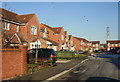
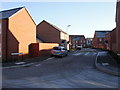
Excelsior Close, Newport
Houses on the west side of Excelsior Close, viewed from near the Argosy Way junction.
Image: © Jaggery
Taken: 4 Jan 2010
0.02 miles
4
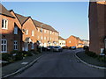
Tantallus Way, Newport
Viewed from Argosy Way, Tantallus Way is part of the Great Western Wharf housing development.
Image: © Jaggery
Taken: 4 Jan 2010
0.02 miles
5
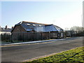
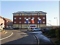
The Bridge training centre, Willenhall Street, Newport
Established in 1997, The Bridge is Newport City Council's training centre.
It is located on the corner of Willenhall Street and Lilleshall Street.
Image: © Jaggery
Taken: 4 Jan 2010
0.05 miles
6
Padma surgery, Newport
Located on Willenhall Street, close to the Corporation Road junction.
Image: © Jaggery
Taken: 4 Jan 2010
0.06 miles
7
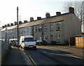
Lilleshall Street, Newport
Houses on the west side of Lilleshall Street, viewed from the Corporation Road end of the street.
Image: © Jaggery
Taken: 4 Jan 2010
0.06 miles
8
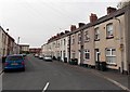
Lilleshall Street, Newport
Viewed from the Corporation Road end looking towards newer houses in Liberty Grove and Seabreeze Avenue.
Image: © Jaggery
Taken: 5 May 2014
0.07 miles
9
Apartment building, Argosy Way, Newport
Part of the Great Western Wharf housing development.
Image: © Jaggery
Taken: 4 Jan 2010
0.08 miles
10
Tantallus Crescent, Newport
Viewed from Argosy Way, Tantallus Crescent is part of the Great Western Wharf housing development.
Image: © Jaggery
Taken: 4 Jan 2010
0.08 miles