IMAGES TAKEN NEAR TO
Harrow Road, NEWPORT, NP19 0BT
Introduction
This page details the photographs taken nearby to Harrow Road, NP19 0BT by members of the Geograph project.
The Geograph project started in 2005 with the aim of publishing, organising and preserving representative images for every square kilometre of Great Britain, Ireland and the Isle of Man.

There are currently over 7.5m images from over14,400 individuals and you can help contribute to the project by visiting https://www.geograph.org.uk
Image Map
Images are licensed for reuse under creativecommons.org/licenses/by-sa/2.0
Notes
- Clicking on the map will re-center to the selected point.
- The higher the marker number, the further away the image location is from the centre of the postcode.
Image Listing (815 Images Found)
Images are licensed for reuse under creativecommons.org/licenses/by-sa/2.0
Image
Details
Distance
1
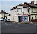
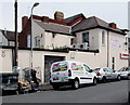
Zam Zam Stores, Newport
Located on the corner of Harrow Road and Bedford Road,
Zam Zam Stores sells groceries and halal meat, poultry and fish.
Image: © Jaggery
Taken: 23 Jun 2016
0.01 miles
2
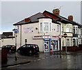
Zam Zam Stores on a Newport corner
Located on the corner of Harrow Road and Bedford Road, Zam Zam Stores sells groceries and halal meat, poultry and fish. In March 2017, a large banner advertising MWG solicitors is on the Bedford Road side of the stores.
Image: © Jaggery
Taken: 21 Mar 2017
0.01 miles
3
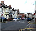
Harrow Road No Entry signs, Newport
One of several pairs of No Entry signs in Harrow Road, this pair is at the Bedford Road crossroads.
Image: © Jaggery
Taken: 11 Mar 2020
0.01 miles
4
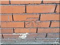
Ordnance Survey Cut Mark
This OS cut mark can be found on No28 Harrow Road. It marks a point 7.574m above mean sea level.
Image: © Adrian Dust
Taken: 9 Jun 2018
0.02 miles
5
Zam Zam Stores van, Newport
Parked in Bedford Road near the Zam Zam Stores shop http://www.geograph.org.uk/photo/5006477 on the corner of Harrow Road.
Image: © Jaggery
Taken: 23 Jun 2016
0.02 miles
6
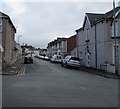
East along Bedford Road, Newport
From Cedar Road along Bedford Road towards Harrow Road.
Image: © Jaggery
Taken: 25 Sep 2017
0.03 miles
7
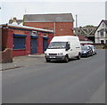
Ring Master UK, Harrow Road, Newport
Shuttered premises viewed at 1.47pm on a Thursday in June 2016.
Image: © Jaggery
Taken: 23 Jun 2016
0.03 miles
8
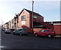
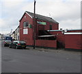
The Arrows, Harrow Road, Newport
Viewed from the corner of Marlborough Road. The banner on the wall shows that this is St Julians HSOB (High School Old Boys) club. Located at 45 Harrow Road, the private members club has c140 members.
Established in 1947, St Julians HSOB club has used many locations in the Newport area as its headquarters. The club moved here in 1983 from its previous location in Palmyra Place on the edge of Newport City Centre.
Image: © Jaggery
Taken: 9 Jan 2013
0.03 miles
9
The Arrows, Harrow Road, Newport
Located opposite Marlborough Road, the Arrows is the location of St Julians HSOB (High School Old Boys) club.
In this context, Old Boy = Former Pupil.
Image: © Jaggery
Taken: 25 Sep 2017
0.03 miles
10
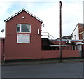
Arrows information board, Harrow Road, Newport
In March 2020 the board states that the Arrows is the home of the St Julians H.S.O.B. Club. (H.S.O.B. = High School Old Boys). New male/female members welcome. Darts - Pool - Shove - Crib - Sky Sports. Newport County Supporters Welcome.
Image: © Jaggery
Taken: 11 Mar 2020
0.03 miles