IMAGES TAKEN NEAR TO
Rugby Road, NEWPORT, NP19 0BS
Introduction
This page details the photographs taken nearby to Rugby Road, NP19 0BS by members of the Geograph project.
The Geograph project started in 2005 with the aim of publishing, organising and preserving representative images for every square kilometre of Great Britain, Ireland and the Isle of Man.

There are currently over 7.5m images from over14,400 individuals and you can help contribute to the project by visiting https://www.geograph.org.uk
Image Map
Images are licensed for reuse under creativecommons.org/licenses/by-sa/2.0
Notes
- Clicking on the map will re-center to the selected point.
- The higher the marker number, the further away the image location is from the centre of the postcode.
Image Listing (652 Images Found)
Images are licensed for reuse under creativecommons.org/licenses/by-sa/2.0
Image
Details
Distance
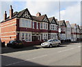
1
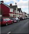
On-street parking, Rugby Road, Newport
Viewed from the corner of Harrow Road looking along Rugby Road towards Eton Road.
Image: © Jaggery
Taken: 11 Mar 2020
0.02 miles
2
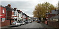
Methuen Road, Newport
Viewed from Eton Road towards Llanwern Street.
Image: © Jaggery
Taken: 28 Oct 2009
0.04 miles
3
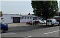
L.C.Motors, Corporation Road, Newport
New and used car sales and servicing business at 121 Corporation Road.
Image: © Jaggery
Taken: 5 May 2014
0.04 miles
4
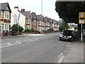
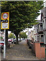
20 when lights show, Corporation Road, Newport
The 30mph speed limit drops to 20mph when lights are showing
at times when young children are likely to be crossing the road.
The path between the gap in houses on the left leads to Maindee Primary School.
Image: © Jaggery
Taken: 23 Jun 2016
0.04 miles
5
Part-time 20 speed limit, Corporation Road, Newport
The 30mph speed limit drops to 20mph when these lights flash, at times when
schoolchildren are likely to be crossing Corporation Road. Maindee Primary School is nearby.
Image: © Jaggery
Taken: 25 Sep 2017
0.04 miles
6
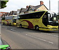
Two Silverdale of Nottingham coaches parked in Corporation Road, Newport
The coaches are on hire to Notts County Supporters Club for the Newport County vs Notts County League Two football match on May 6th 2017 at nearby Rodney Parade. Viewed 40 minutes before kickoff.
Image: © Jaggery
Taken: 6 May 2017
0.05 miles
7
Eton Road houses, Newport
Between Corporation Road and Rugby Road.
Image: © Jaggery
Taken: 25 Sep 2017
0.05 miles
8
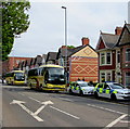
Police cars and football supporters club coaches, Corporation Road, Newport
Parked alongside Corporation Road near an entrance to Rodney Parade, where Newport County will play Notts County in a League Two football match. Kickoff is in 40 minutes. The coaches http://www.geograph.org.uk/photo/5392254 are on hire to Notts County Supporters Club.
Image: © Jaggery
Taken: 6 May 2017
0.05 miles
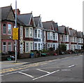
9
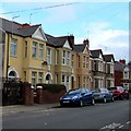
Row of houses, Corporation Road, Newport
Between Eton Road and Harrow Road.
Image: © Jaggery
Taken: 11 Mar 2020
0.05 miles
10
Yellow sign on a Corporation Road lamppost, Newport
On the approach to Maindee Primary School, the sign shows No Stopping Mon - Fri 8am - 4.30pm 1 Sept - 31 July on entrance markings. The text is also in Welsh.
Image: © Jaggery
Taken: 11 Mar 2020
0.05 miles