IMAGES TAKEN NEAR TO
Rugby Road, NEWPORT, NP19 0BR
Introduction
This page details the photographs taken nearby to Rugby Road, NP19 0BR by members of the Geograph project.
The Geograph project started in 2005 with the aim of publishing, organising and preserving representative images for every square kilometre of Great Britain, Ireland and the Isle of Man.

There are currently over 7.5m images from over14,400 individuals and you can help contribute to the project by visiting https://www.geograph.org.uk
Image Map
Images are licensed for reuse under creativecommons.org/licenses/by-sa/2.0
Notes
- Clicking on the map will re-center to the selected point.
- The higher the marker number, the further away the image location is from the centre of the postcode.
Image Listing (562 Images Found)
Images are licensed for reuse under creativecommons.org/licenses/by-sa/2.0
Image
Details
Distance
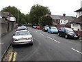
1
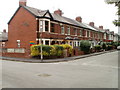
Malvern Road, Newport
Extending for 65 metres from Corporation Road to Rugby Road.
Image: © Jaggery
Taken: 23 Jun 2016
0.01 miles
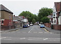
2
On-street parking, Malvern Road, Newport
Viewed from Corporation Road looking along Malvern Road towards Rugby Road.
Image: © Jaggery
Taken: 25 Sep 2017
0.01 miles
3
Llanwern Street, Newport
Houses on the east side of Llanwern Street, looking towards Corporation Road. The tops of the towers of George Street Bridge can be seen just above the rooftops at the end of the street.
Image: © Jaggery
Taken: 28 Oct 2009
0.03 miles
4
Too old at 11 : Rugby Road, Newport
A sign at the Rugby Road entrance to a play area states that
THIS PLAY AREA HAS BEEN PROVIDED FOR USE BY CHILDREN OF 5-10 YEARS OF AGE.
The other three sides of the rectangular play area are bordered by Cambridge Road, Methuen Road and Kingston Road.
Image: © Jaggery
Taken: 1 Aug 2010
0.04 miles
5
Cambridge Road, Newport
Viewed from Rugby Road. The houses are all on the west side of Cambridge Road. On the other side is the perimeter of a rectangular play area for children aged 5-10. http://www.geograph.org.uk/photo/1999450
Image: © Jaggery
Taken: 1 Aug 2010
0.04 miles
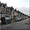
6
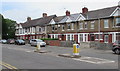
Corporation Road houses, Newport
Between Eton Road (out of shot on the left) and Malvern Road.
Image: © Jaggery
Taken: 23 Jun 2016
0.04 miles
7
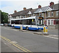
NAT bus, Corporation Road, Newport
The NAT (New Adventure Travel) Group Optare bus, fleet number 517, is on
route N4 from Market Square bus station in the city centre to Spytty Retail Park.
Viewed in June 2016 when NAT buses have become a common sight in some parts of Newport,
though Newport Bus remains the major provider of bus services in the city,
and their buses are seen on many more routes than NAT.
Image: © Jaggery
Taken: 23 Jun 2016
0.04 miles
8
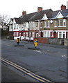
Corporation Road pedestrian refuge, Newport
Between Keep Left signs near the Malvern Road junction.
Image: © Jaggery
Taken: 11 Mar 2020
0.04 miles
9
June 23rd 2016 polling station in Eton Road, Newport
The Presbyterian Church of Wales Community House is in use today
as a polling station for the June 23rd 2016 UK EU Referendum.
The polling station is open from 7am until 10pm.
Image: © Jaggery
Taken: 23 Jun 2016
0.04 miles
10
Row of houses, Corporation Road, Newport
The 50 metre long row of Corporation Road houses is between
Malvern Road on the right and Eton Road out of shot ahead.
Image: © Jaggery
Taken: 13 Mar 2013
0.04 miles