IMAGES TAKEN NEAR TO
Priory Close, NEWPORT, NP18 3SY
Introduction
This page details the photographs taken nearby to Priory Close, NP18 3SY by members of the Geograph project.
The Geograph project started in 2005 with the aim of publishing, organising and preserving representative images for every square kilometre of Great Britain, Ireland and the Isle of Man.

There are currently over 7.5m images from over14,400 individuals and you can help contribute to the project by visiting https://www.geograph.org.uk
Image Map
Images are licensed for reuse under creativecommons.org/licenses/by-sa/2.0
Notes
- Clicking on the map will re-center to the selected point.
- The higher the marker number, the further away the image location is from the centre of the postcode.
Image Listing (74 Images Found)
Images are licensed for reuse under creativecommons.org/licenses/by-sa/2.0
Image
Details
Distance
1
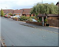
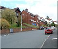
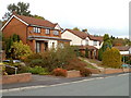
Priory Close, Caerleon
Houses on the south side of Priory Close, viewed from near the corner of Trinity View. Priory Close is built along a narrow ridge in a generally hilly area. Compare the steepness of nearby Pollard Close. http://www.geograph.org.uk/photo/2113914
Image: © Jaggery
Taken: 16 Oct 2010
0.03 miles
2
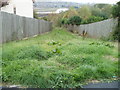
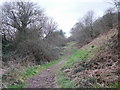
Grassy descent from Trinity View, Caerleon
Opposite a bend at the northernmost point of Trinity View, a grassy track descends steeply towards a small wooded area named Hill Croft. In the distance, at a much lower level, is the River Usk.
Image: © Jaggery
Taken: 16 Oct 2010
0.06 miles
3
Houses above the north side of Trinity View, Caerleon
The backs of houses on the south side of Pollard Close.
Image: © Jaggery
Taken: 31 Dec 2018
0.06 miles
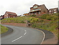
5
Caerleon : Trinity View NE of Parkwood Close
Houses on the north side of Trinity View, near the end of a steep climb up from Pillmawr Road.
The broken white lines on the left edge of the photo are at the junction with Parkwood Close.
Image: © Jaggery
Taken: 16 Oct 2010
0.08 miles
6
Western arm of Trinity View, Caerleon
Viewed from the corner of Pillmawr Road, Trinity View heads away to the northwest then loops around to rejoin Pillmawr Road about 100 metres to the east.
Image: © Jaggery
Taken: 14 Jun 2010
0.09 miles
7
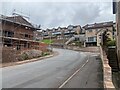
Filling the gap, Trinity View, Caerleon
In the four months since this photo, http://www.geograph.org.uk/photo/1913896 new houses have filled in the gap at the SW end of Trinity View, viewed from the corner of Pillmawr Road.
Image: © Jaggery
Taken: 16 Oct 2010
0.09 miles
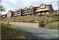
8
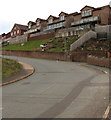
Pollard Close, Caerleon
Modern houses on the north side of Pillmawr Road, at the western edge of residential Caerleon, are built around an area known as Hill Croft. 'Hill' is an appropriate word for much of this area, as shown in this view of Pollard Close, which rises steeply away from Trinity View, the principal road through the area.
Image: © Jaggery
Taken: 16 Oct 2010
0.09 miles
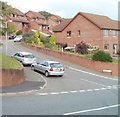
9
Flattish central section of Trinity View, Caerleon
Trinity View follows a roughly horseshoe-shaped course on the north side of Pillmawr Road. Its western and eastern arms, both connecting with Pillmawr Road, are steep. This view of houses on the northern side of the central section shows that the roadway is fairly level here, though the houses are on ground at a slightly higher elevation.
Image: © Jaggery
Taken: 16 Oct 2010
0.10 miles
10
Track through Lodge Wood, Caerleon
A track heads westwards along the southern edge of Lodge Wood.
Image: © Jaggery
Taken: 5 Apr 2010
0.10 miles