IMAGES TAKEN NEAR TO
Pillmawr Road, NEWPORT, NP18 3QZ
Introduction
This page details the photographs taken nearby to Pillmawr Road, NP18 3QZ by members of the Geograph project.
The Geograph project started in 2005 with the aim of publishing, organising and preserving representative images for every square kilometre of Great Britain, Ireland and the Isle of Man.

There are currently over 7.5m images from over14,400 individuals and you can help contribute to the project by visiting https://www.geograph.org.uk
Image Map
Images are licensed for reuse under creativecommons.org/licenses/by-sa/2.0
Notes
- Clicking on the map will re-center to the selected point.
- The higher the marker number, the further away the image location is from the centre of the postcode.
Image Listing (106 Images Found)
Images are licensed for reuse under creativecommons.org/licenses/by-sa/2.0
Image
Details
Distance
1
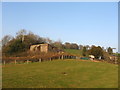
Lodge Hill
Old Farm buildings on Lodge Hill.
Image: © David Roberts
Taken: 19 Mar 2009
0.02 miles
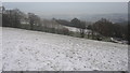
2
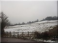
Hillside Farmland
Hillside farmland near Malpas, seen after the snow in February 2009.
Image: © David Roberts
Taken: 5 Feb 2009
0.05 miles
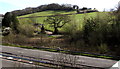
3
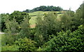
Lodge Wood, Caerleon viewed from Malpas, Newport
Viewed from the bridge http://www.geograph.org.uk/photo/1451157 carrying Pillmawr Road over the A4042. The distant trees are at the SW edge of Lodge Wood, located on Lodge Hill.
Image: © Jaggery
Taken: 13 Jul 2011
0.05 miles
5
Lodge Hillside in the Snow
The hillside of Lodge Hill covered in snow, looking towards the rooftops of east Newport.
Image: © David Roberts
Taken: 24 Dec 2009
0.08 miles
6
Hillside viewed from Pillmawr Road, Newport
Looking to the ENE across the A4042.
Image: © Jaggery
Taken: 7 Apr 2020
0.09 miles
7
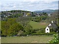
View from Pillmawr Road near Caerleon
Looking across Pwll-Mawr farm towards the Malpas area of Newport.
The highest point on the right is Mynydd Machen Image
Image: © Robin Drayton
Taken: 29 Apr 2009
0.09 miles
8
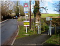
Cycle route and footpath barrier facing Pillmawr Road, Newport
The barrier prevents motor vehicle misuse of the cycle route and footpath to Caerleon, part of National Cycle Network Route 88. The text below the exclamation mark triangular sign warns "When lights flash route flooded".
Image: © Jaggery
Taken: 26 Feb 2015
0.10 miles
9
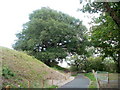
Oak Tree, Malpas to Caerleon cycle route
The tree is near the first bend at the Malpas side of the footpath and cycle route to Caerleon. The land on the left rises steeply away from the north bank of the River Usk, just out of shot on the right.
Image: © Jaggery
Taken: 16 Oct 2010
0.10 miles
10
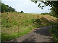
Steep ground at the edge of the Malpas to Caerleon cycleway and footpath, Newport
Viewed from near the Pillmawr Road, Malpas, end of the route, which here follows a flat course along the north bank of the River Usk, at the edge of steep ground on its northern side.
Image: © Jaggery
Taken: 20 Jun 2012
0.10 miles