IMAGES TAKEN NEAR TO
Eastfield Drive, NEWPORT, NP18 3FZ
Introduction
This page details the photographs taken nearby to Eastfield Drive, NP18 3FZ by members of the Geograph project.
The Geograph project started in 2005 with the aim of publishing, organising and preserving representative images for every square kilometre of Great Britain, Ireland and the Isle of Man.

There are currently over 7.5m images from over14,400 individuals and you can help contribute to the project by visiting https://www.geograph.org.uk
Image Map
Images are licensed for reuse under creativecommons.org/licenses/by-sa/2.0
Notes
- Clicking on the map will re-center to the selected point.
- The higher the marker number, the further away the image location is from the centre of the postcode.
Image Listing (66 Images Found)
Images are licensed for reuse under creativecommons.org/licenses/by-sa/2.0
Image
Details
Distance
1
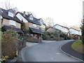
Owen Close, Caerleon
Owen Close climbs away from College Glade.
Image: © Jaggery
Taken: 11 Feb 2010
0.10 miles
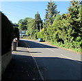
2
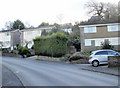
College Glade, Caerleon
Houses on the south side of College Glade. College Glade is a central road in an
area of houses in the north of Caerleon. Seen here, it is climbing away from Ponthir Road at the start of a long, steep climb. The route taken by College Glade is horseshoe shaped.
Image: © Jaggery
Taken: 11 Feb 2010
0.10 miles
3
Webley Close, Caerleon
Looking towards the far end of Webley Close, from the corner of Webley Gardens.
Image: © Jaggery
Taken: 11 Feb 2010
0.13 miles
4
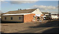
Beds Direct, Caerleon
Unit 4, Boxer Trading Estate, Ponthir Road, Caerleon.
Image: © Jaggery
Taken: 11 Feb 2010
0.13 miles
5
College Glade bus stops, Caerleon
There is a bus stop sign on a lamppost on the right. The bus stop sign for services in the opposite direction is near the hedge on the left. There are no bus shelters here, near the Ponthir Road junction.
Image: © Jaggery
Taken: 8 Apr 2013
0.14 miles
6
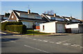
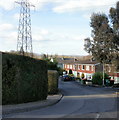
Corner of Orchard Road, Caerleon
Houses on the west side of Orchard Road, viewed from near the point where College Glade ends and Eastfield Road begins.
Image: © Jaggery
Taken: 11 Feb 2010
0.14 miles
7
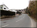
Northern end of College Glade, Caerleon
A viewed SSW from the Ponthir Road end.
Image: © Jaggery
Taken: 8 Apr 2013
0.15 miles
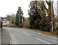
8
Malthouse Lane heading for Lower Malthouse Farm
The National Speed Limit sign indicating the end of urban speed restrictions is at the eastern start of Malthouse Lane. The next sign a little way ahead warns of bends for 2 miles.
Lower Malthouse Farm http://www.geograph.org.uk/photo/1189770 can be seen in the distance.
Image: © Jaggery
Taken: 11 Feb 2010
0.15 miles
9
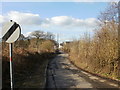
Northwest end of College Glade, Caerleon
Viewed from the corner of Ponthir Road.
Image: © Jaggery
Taken: 25 Sep 2018
0.15 miles
10
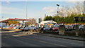
Caerleon Cars, Ponthir Road
Used car dealers located on Ponthir Road, next door to Spar.
Image: © Jaggery
Taken: 11 Feb 2010
0.16 miles