IMAGES TAKEN NEAR TO
Nash, NEWPORT, NP18 2YH
Introduction
This page details the photographs taken nearby to NP18 2YH by members of the Geograph project.
The Geograph project started in 2005 with the aim of publishing, organising and preserving representative images for every square kilometre of Great Britain, Ireland and the Isle of Man.

There are currently over 7.5m images from over14,400 individuals and you can help contribute to the project by visiting https://www.geograph.org.uk
Image Map
Images are licensed for reuse under creativecommons.org/licenses/by-sa/2.0
Notes
- Clicking on the map will re-center to the selected point.
- The higher the marker number, the further away the image location is from the centre of the postcode.
Image Listing (17 Images Found)
Images are licensed for reuse under creativecommons.org/licenses/by-sa/2.0
Image
Details
Distance
1
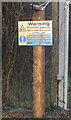
Potentially explosive atmospheres, Nash
A sign at the entrance gate to Nash Waste Water Treatment Works http://www.geograph.org.uk/photo/1864585 warns of potentially explosive atmospheres ahead.
Image: © Jaggery
Taken: 23 Jan 2010
0.06 miles
2
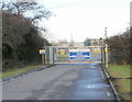
Entrance to Nash Waste Water Treatment Works
Welsh Water Asset 30996, located on the north side of West Nash Road.
The sign http://www.geograph.org.uk/photo/1864592 on the left warns of potentially explosive atmospheres on the site.
Image: © Jaggery
Taken: 23 Jan 2010
0.06 miles
3
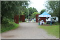
Car park exit, RSPB Visitor Centre
Exit from pay car park to West Nash Road.
Image: © M J Roscoe
Taken: 23 Aug 2021
0.17 miles
4
![Orchid at Newport Wetlands [4]](https://s1.geograph.org.uk/geophotos/01/36/65/1366553_1df8beb7_120x120.jpg)
Orchid at Newport Wetlands [4]
Bee Orchid (Ophrys apifera).
Image: © Robin Drayton
Taken: 20 Jun 2009
0.19 miles
5
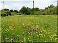
Orchids and Buttercups on the Newport Wetlands Reserve
Southern marsh orchids (Dactylorhiza praetermissa).
Image: © Robin Drayton
Taken: 3 Jun 2009
0.20 miles
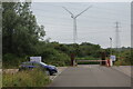
6
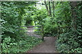
Track to Visitor Centre, Newport Wetlands
The arrows on the wooden post indicate various trails in and around the wetlands.
Image: © M J Roscoe
Taken: 23 Aug 2021
0.20 miles
7
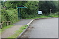
Bus shelter, car park at RSPB Visitor Centre
The wooden signpost indicates the route of the Wales Coast Path into the nature reserve.
Image: © M J Roscoe
Taken: 23 Aug 2021
0.21 miles
8

Entrance to the Uskmouth Power Station site
This is the coal-fired Uskmouth B plant.
A gas turbine plant is currently under construction on the site http://www.geograph.org.uk/photo/1346766 .
Image: © Robin Drayton
Taken: 3 Jun 2009
0.21 miles

10
Pedestrian route to RSPB car park from Perry Lane
The Wales Coast Path goes through the barrier and turns to the left.
Image: © M J Roscoe
Taken: 23 Aug 2021
0.22 miles