IMAGES TAKEN NEAR TO
Whitson, NEWPORT, NP18 2PN
Introduction
This page details the photographs taken nearby to NP18 2PN by members of the Geograph project.
The Geograph project started in 2005 with the aim of publishing, organising and preserving representative images for every square kilometre of Great Britain, Ireland and the Isle of Man.

There are currently over 7.5m images from over14,400 individuals and you can help contribute to the project by visiting https://www.geograph.org.uk
Image Map
Images are licensed for reuse under creativecommons.org/licenses/by-sa/2.0
Notes
- Clicking on the map will re-center to the selected point.
- The higher the marker number, the further away the image location is from the centre of the postcode.
Image Listing (81 Images Found)
Images are licensed for reuse under creativecommons.org/licenses/by-sa/2.0
Image
Details
Distance
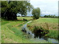
1
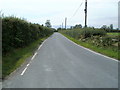
Road from Whitson towards Goldcliff
A view SSW from the road junction at Porton Corner in the low-lying land of the Caldicot Level.
Image: © Jaggery
Taken: 12 Aug 2011
0.01 miles
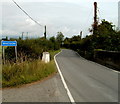
2
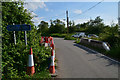
Northern approach to Monk's Ditch bridge, Whitson
Road signs show that the roadway narrows ahead, across the humpback bridge over Monk's Ditch,
a major reen, one of the many channels draining the flat, low-lying land of the Caldicot Level.
Image: © Jaggery
Taken: 12 Aug 2011
0.01 miles
3
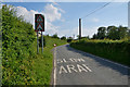
Newport District : Whitson Common Road
Looking along a road as it approaches a bend.
Image: © Lewis Clarke
Taken: 1 Jun 2017
0.02 miles
4
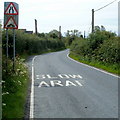
Newport District : Whitson Common Road
Looking along the road with a sign welcoming people to Goldcliff.
Image: © Lewis Clarke
Taken: 1 Jun 2017
0.03 miles
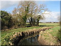
5
Monk's Ditch, Whitson and Goldcliff
Monk's Ditch is a major channel draining the low-lying Caldicot Level.
It here marks the village boundary between Whitson on the right and Goldcliff on the left.
Image: © Jaggery
Taken: 12 Aug 2011
0.03 miles
6
Southern boundary of Whitson
The boundary sign is at the edge of the bridge carrying the road over Monk's Ditch, a major channel draining the low-lying Caldicot Level. The Goldcliff boundary sign http://www.geograph.org.uk/photo/3559566 is on the opposite side of the bridge.
Image: © Jaggery
Taken: 12 Aug 2011
0.04 miles
8
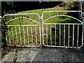
Whitson and Goldcliff Silver Jubilee gates
The gates were installed at the northern edge of the former schoolhouse and schoolroom http://www.geograph.org.uk/photo/607192
to mark Queen Elizabeth II's Silver Jubilee in 1977.
Image: © Jaggery
Taken: 12 Aug 2011
0.04 miles
9
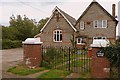
Former school house
Part of the former schoolhouse for Whitson is now a private residence, while the adjoining northern part is still used regularly as a community meeting place.
Image: © Graham Horn
Taken: 17 Aug 2008
0.04 miles
10
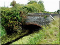
Whitson Arch Bridge
The road bridge spans Monk's Ditch, a major channel draining the low-lying Caldicot Level, and here marking the village boundary between Goldcliff on this side and Whitson on the opposite side of the water.
Image: © Jaggery
Taken: 12 Aug 2011
0.04 miles