IMAGES TAKEN NEAR TO
Whitson, NEWPORT, NP18 2PG
Introduction
This page details the photographs taken nearby to NP18 2PG by members of the Geograph project.
The Geograph project started in 2005 with the aim of publishing, organising and preserving representative images for every square kilometre of Great Britain, Ireland and the Isle of Man.

There are currently over 7.5m images from over14,400 individuals and you can help contribute to the project by visiting https://www.geograph.org.uk
Image Map
Images are licensed for reuse under creativecommons.org/licenses/by-sa/2.0
Notes
- Clicking on the map will re-center to the selected point.
- The higher the marker number, the further away the image location is from the centre of the postcode.
Image Listing (23 Images Found)
Images are licensed for reuse under creativecommons.org/licenses/by-sa/2.0
Image
Details
Distance
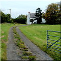
1
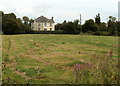
The Orchards, Whitson
House set back 100 metres from Whitson Common Road.
Image: © Jaggery
Taken: 12 Aug 2011
0.04 miles
2
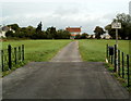
Upfield Farm, Whitson
Viewed from Whitson Common Road.
Image: © Jaggery
Taken: 12 Aug 2011
0.07 miles
3
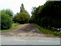
Half Acre Lane, Whitson
Looking NE from Whitson Common Road.
Here's http://www.geograph.org.uk/photo/148591 an earlier view of another part of the lane.
Image: © Jaggery
Taken: 12 Aug 2011
0.10 miles
4
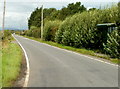
Whitson Common Road, Whitson
A view NNW from Porton Corner.
The green bus shelter on the right is doing its best to appear inconspicuous in the vegetation.
Image: © Jaggery
Taken: 12 Aug 2011
0.13 miles
5
Hall opposite Half Acre Lane, Whitson
Viewed from Whitson Common Road. At the August 2011 date of this view, there was no name on the building and weeds were growing around the entrance, so it appears to have been disused at that time.
Image: © Jaggery
Taken: 12 Aug 2011
0.13 miles
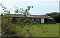
6
Reen near Manor House Farm, Whitson
The reen (a local word) is part of an extensive network of channels draining the low-lying Caldicot Level.
Image: © Jaggery
Taken: 12 Aug 2011
0.14 miles
7
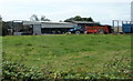
Pill Farm, Whitson
Viewed from Whitson Common Road.
Image: © Jaggery
Taken: 12 Aug 2011
0.14 miles
8
Manor House Farm, Whitson
Viewed from Whitson Common Road.
Image: © Jaggery
Taken: 12 Aug 2011
0.15 miles
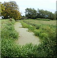
9
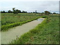
A reen on Whitson Common
The reen (a local word) is part of an extensive network of channels draining the low-lying Caldicot Level.
Image: © Jaggery
Taken: 12 Aug 2011
0.17 miles
10
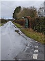
Dark green bus shelter, Whitson
Alongside Whitson Common Road near the Porton Road junction.
Image: © Jaggery
Taken: 12 Dec 2021
0.18 miles