IMAGES TAKEN NEAR TO
Stockwood View, NEWPORT, NP18 2NS
Introduction
This page details the photographs taken nearby to Stockwood View, NP18 2NS by members of the Geograph project.
The Geograph project started in 2005 with the aim of publishing, organising and preserving representative images for every square kilometre of Great Britain, Ireland and the Isle of Man.

There are currently over 7.5m images from over14,400 individuals and you can help contribute to the project by visiting https://www.geograph.org.uk
Image Map
Images are licensed for reuse under creativecommons.org/licenses/by-sa/2.0
Notes
- Clicking on the map will re-center to the selected point.
- The higher the marker number, the further away the image location is from the centre of the postcode.
Image Listing (60 Images Found)
Images are licensed for reuse under creativecommons.org/licenses/by-sa/2.0
Image
Details
Distance
1

Telephone Exchange, Langstone
Situated off Chepstow Road (A48), this TE would appear to date from the 1960s, having replaced the former TE in nearby Llanwern. It has the code SWUWN and provides telephone and broadband services to 2,158 residential and 62 non-residential premises in Langstone plus Bishton, Llanmartin and Llanwern nearby. The numbering range of this TE is (01633) 41xxxx, the (01633) referring to the Newport(Gwent) group of thirteen TEs, and its postcode is NP18 2LU.
Image: © David Hillas
Taken: 26 Apr 2019
0.05 miles
2
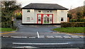
Greenfields Private Nursery, Langstone
The private nursery school, located on the north side of Chepstow Road, opened in 1999. It caters for 46 children, from newborn to age 5.
Image: © Jaggery
Taken: 15 Nov 2009
0.05 miles
3
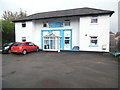
Little Darlings Private Nursery, Langstone
Situated in Chepstow Road NP18 2LU, this private nursery used to be known as the Greenfields Private Nursery, https://www.geograph.org.uk/photo/1988366 refers. It is one of a few Little Darlings Nursery in England and Wales with places for a total of forty children with an age range between three months and twelve years.
Image: © David Hillas
Taken: 26 Apr 2019
0.06 miles
4
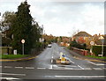
Catsash Road, Langstone
Catsash Road heads away from the A48 Chepstow Road, Langstone towards Cat's Ash.
Note the difference between the name of the road (as shown on maps and on the road name signs at lower left and lower right of the photo) and the hamlet of Cat's Ash.
Image: © Jaggery
Taken: 15 Nov 2009
0.08 miles
6
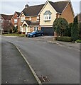
Silure Way houses, Langstone
This https://www.geograph.org.uk/photo/7387627 Catsash Road mini-roundabout is behind the camera.
Image: © Jaggery
Taken: 22 Jan 2023
0.09 miles
7
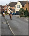
Two horse riders, Silure Way, Langstone
On a Sunday in January 2023.
Image: © Jaggery
Taken: 22 Jan 2023
0.09 miles
8
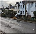
Catsash Road houses, Langstone
Some older reference sources show Cat's Ash Road.
Image: © Jaggery
Taken: 22 Jan 2023
0.09 miles
9
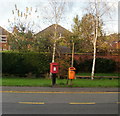
Langstone postbox
An unusually squat postbox http://www.geograph.org.uk/photo/1667968 located on Chepstow Road (A48) Langstone, between the Catsash Road turning and a bus stop.
Image: © Jaggery
Taken: 15 Nov 2009
0.09 miles
10
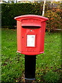
Closeup of squat Langstone postbox
The postbox is on the A48 Chepstow Road. http://www.geograph.org.uk/photo/1667963
Image: © Jaggery
Taken: 15 Nov 2009
0.09 miles