IMAGES TAKEN NEAR TO
Catsash Road, NEWPORT, NP18 2LZ
Introduction
This page details the photographs taken nearby to Catsash Road, NP18 2LZ by members of the Geograph project.
The Geograph project started in 2005 with the aim of publishing, organising and preserving representative images for every square kilometre of Great Britain, Ireland and the Isle of Man.

There are currently over 7.5m images from over14,400 individuals and you can help contribute to the project by visiting https://www.geograph.org.uk
Image Map
Images are licensed for reuse under creativecommons.org/licenses/by-sa/2.0
Notes
- Clicking on the map will re-center to the selected point.
- The higher the marker number, the further away the image location is from the centre of the postcode.
Image Listing (53 Images Found)
Images are licensed for reuse under creativecommons.org/licenses/by-sa/2.0
Image
Details
Distance
1
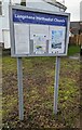
Langstone Methodist Church information board
In January 2023 one of the notices on the board
located here https://www.geograph.org.uk/photo/7387614 shows "Sunday Service at 6pm"
Image: © Jaggery
Taken: 22 Jan 2023
0.01 miles
2
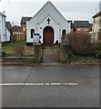
Langstone Methodist Church, Newport
Part of the Newport & Lower Wye Methodist Circuit
viewed across Catsash Road in January 2023.
Image: © Jaggery
Taken: 22 Jan 2023
0.01 miles
3
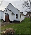
Langstone Methodist Church
Part of the Newport & Lower Wye Methodist Circuit, Langstone Methodist Church is
on the west side of Catsash Road. The church foundation stones show the year 1927.
Image: © Jaggery
Taken: 22 Jan 2023
0.01 miles
4
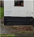
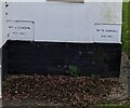
Two church foundation stones, Catsash Road, Langstone
The stones are on the left side of the entrance to Langstone Methodist Church. https://www.geograph.org.uk/photo/7387614
The stone on the left shows MRS J. PALMER MAY 1927
The stone on the right shows MRS H.M. BYTHWAY MAY 1927
Image: © Jaggery
Taken: 22 Jan 2023
0.01 miles
5
Church foundation stones dated May 1927, Catsash Road, Langstone
The stones are on the right side of the entrance to Langstone Methodist Church. https://www.geograph.org.uk/photo/7387614
The stone on the left shows MRS J. DAWSON MAY 1927
The stone on the right shows MRS E. KENDALL MAY 1927
Image: © Jaggery
Taken: 22 Jan 2023
0.01 miles
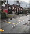
6
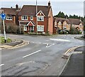
Eastern end of Silure Way, Langstone
On the approach to the mini-roundabout in the middle of Catsash Road.
Image: © Jaggery
Taken: 22 Jan 2023
0.01 miles
7
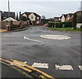
Mini-roundabout, Catsash Road, Langstone
View from Rosecroft Drive looking across Catsash Road towards Silure Way.
Image: © Jaggery
Taken: 22 Jan 2023
0.01 miles
8
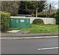
Silure Way Sewage Pumping Station, Langstone
Welsh Water Asset 72772 on the north side of Silure Way near the Catsash Road junction.
Image: © Jaggery
Taken: 22 Jan 2023
0.02 miles
9
Houses on the east side of Catsash Road, Langstone
On the approach to this https://www.geograph.org.uk/photo/7387627 mini-roundabout.
Image: © Jaggery
Taken: 22 Jan 2023
0.02 miles
10
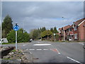
Mini-roundabout, Langstone, near Newport.
Image: © Ruth Sharville
Taken: 10 Mar 2007
0.02 miles