IMAGES TAKEN NEAR TO
Caerlicyn Lane, NEWPORT, NP18 2JZ
Introduction
This page details the photographs taken nearby to Caerlicyn Lane, NP18 2JZ by members of the Geograph project.
The Geograph project started in 2005 with the aim of publishing, organising and preserving representative images for every square kilometre of Great Britain, Ireland and the Isle of Man.

There are currently over 7.5m images from over14,400 individuals and you can help contribute to the project by visiting https://www.geograph.org.uk
Image Map
Images are licensed for reuse under creativecommons.org/licenses/by-sa/2.0
Notes
- Clicking on the map will re-center to the selected point.
- The higher the marker number, the further away the image location is from the centre of the postcode.
Image Listing (5 Images Found)
Images are licensed for reuse under creativecommons.org/licenses/by-sa/2.0
Image
Details
Distance
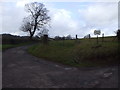
2

Bend in the road, Caerlicken Lane
Footpath sign and stile can also be seen - and the chevron isn't kidding...
Image: © Ruth Sharville
Taken: 10 Mar 2007
0.09 miles
3
Caerlicken Lane, track to Great Caer Licyn Farm
Image: © John Lord
Taken: 5 Feb 2010
0.16 miles
4
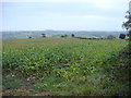
Maize Field looking down towards Hendrew farm
Image: © Andrew Davis
Taken: 21 Sep 2007
0.24 miles
5
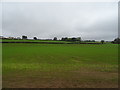
Young crop field off Chepstow Road, Llanbeder
Image: © JThomas
Taken: 15 Oct 2019
0.25 miles