IMAGES TAKEN NEAR TO
Pencoed View, NEWPORT, NP18 2EG
Introduction
This page details the photographs taken nearby to Pencoed View, NP18 2EG by members of the Geograph project.
The Geograph project started in 2005 with the aim of publishing, organising and preserving representative images for every square kilometre of Great Britain, Ireland and the Isle of Man.

There are currently over 7.5m images from over14,400 individuals and you can help contribute to the project by visiting https://www.geograph.org.uk
Image Map
Images are licensed for reuse under creativecommons.org/licenses/by-sa/2.0
Notes
- Clicking on the map will re-center to the selected point.
- The higher the marker number, the further away the image location is from the centre of the postcode.
Image Listing (32 Images Found)
Images are licensed for reuse under creativecommons.org/licenses/by-sa/2.0
Image
Details
Distance
1
Pencoed Lane, Llanmartin
Pencoed Lane heads away east from Magor Road (B4245).
Image: © Jaggery
Taken: 14 Aug 2010
0.02 miles
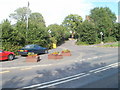
2
Junction of Pencoed Lane and the B4245
Image: © Ruth Sharville
Taken: 19 Apr 2007
0.06 miles
3
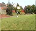
Heron sculpture, Llanmartin
A metal heron is beneath a Croeso (Welsh for welcome) sign on a strip of green adjacent to the corner of Magor Road and Pencoed Lane. The sculpture was made by local craftsman Tony Ford.
Image: © Jaggery
Taken: 14 Aug 2010
0.06 miles
4
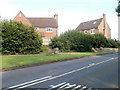
Llanmartin houses
The houses are set back from the east side of Magor Road (B4245).
Image: © Jaggery
Taken: 14 Aug 2010
0.06 miles
5
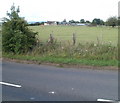
Looking towards Pencoed Lane
The view north from the B4245 (Magor Road) through a gap in the hedge across fields towards buildings on Pencoed Lane.
Image: © Jaggery
Taken: 14 Aug 2010
0.07 miles
6
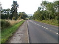
30 mph speed limit through Llanmartin
White markings on the surface of the B4245 Magor Road alert drivers to the imminent 30mph speed limit. This is the SE entrance to Llanmartin.
Image: © Jaggery
Taken: 14 Aug 2010
0.10 miles
7
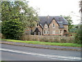
Hollyberry Hall, Llanmartin
Located on the west side of Magor Road, close to the turning for Pencoed Lane.
Image: © Jaggery
Taken: 14 Aug 2010
0.10 miles
8
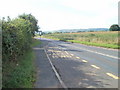
Rural bus stop, Llanmartin
Although within the village of Llanmartin, the bus stop is in an area with fields on both sides of the road.
Image: © Jaggery
Taken: 14 Aug 2010
0.12 miles
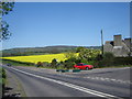
9
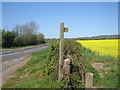
Footpath, oilseed rape field and the B4245
I have noticed the amount of oilseed rape in this area of South Wales more this year (2007) than before. Has it become more popular, or is it down to the joy of Geographing that I'm now more observant?
Image: © Ruth Sharville
Taken: 19 Apr 2007
0.13 miles
10
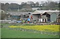
Newport : Church Farm
Looking across towards a farm and barns in the Newport area.
Image: © Lewis Clarke
Taken: 11 Apr 2014
0.18 miles