IMAGES TAKEN NEAR TO
Station Road, NEWPORT, NP18 2DW
Introduction
This page details the photographs taken nearby to Station Road, NP18 2DW by members of the Geograph project.
The Geograph project started in 2005 with the aim of publishing, organising and preserving representative images for every square kilometre of Great Britain, Ireland and the Isle of Man.

There are currently over 7.5m images from over14,400 individuals and you can help contribute to the project by visiting https://www.geograph.org.uk
Image Map
Images are licensed for reuse under creativecommons.org/licenses/by-sa/2.0
Notes
- Clicking on the map will re-center to the selected point.
- The higher the marker number, the further away the image location is from the centre of the postcode.
Image Listing (79 Images Found)
Images are licensed for reuse under creativecommons.org/licenses/by-sa/2.0
Image
Details
Distance
1
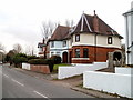
Two semis, Station Road, Llanwern
There is a wide variety of design in houses on Station Road. These two semi-detached houses are named Streamvale and Braeside.
Image: © Jaggery
Taken: 26 Nov 2010
0.03 miles
2
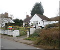
Station Road bungalow, Llanwern
Located on the west side of Station Road, to the south of the Bishton Road junction.
Image: © Jaggery
Taken: 26 Nov 2010
0.04 miles
4
Bishton Road,Llanwern
Looking away from the junction with Station Road, Llanwern
Image: © Jaggery
Taken: 18 Oct 2009
0.06 miles
5
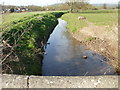
Monksditch drainage channel
Viewed from Bishton Road, about 50 metres east of the junction with Station Road, Llanwern.
The drainage channel empties into the Severn Estuary at Goldcliff.
Image: © Jaggery
Taken: 9 Apr 2010
0.06 miles
6
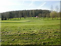
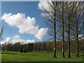
Llanwern Golf Course
The eastern edge of the course, viewed from Station Road. The course extends west for about a kilometre, to the edge of Hartridge High School's playing fields.
In the distance is Dockwell Wood.
Image: © Jaggery
Taken: 9 Apr 2010
0.08 miles
7
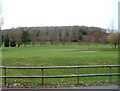
Llanwern golf course viewed from Station Road
The eastern edge of Llanwern golf course viewed through a 75 metre gap between houses on Station Road. In the distance is Dockwell Wood.
Image: © Jaggery
Taken: 26 Nov 2010
0.08 miles
8
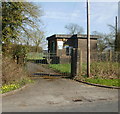
Llanwern Sewage Pumping Station
An essential part of the infrastructure, located on the east side of Station Road.
Image: © Jaggery
Taken: 9 Apr 2010
0.09 miles
9
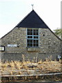
Llanwern Village Institute
Now used infrequently, as evidenced by the weeds in front of the building, in its heyday the Institute was the focus of much village activity. The decline in its usage followed the withdrawal of a regular "inconvenience payment" to village funds from British Steel as production at the nearby once-massive steelworks dwindled.
Image: © Jaggery
Taken: 18 Oct 2009
0.10 miles
10
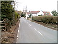
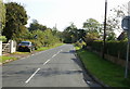
Station Road, Llanwern
The view north along Station Road, between the Bishton Road http://www.geograph.org.uk/photo/1544653 turning (behind the camera) and Milton Hill.
Image: © Jaggery
Taken: 26 Nov 2010
0.10 miles