IMAGES TAKEN NEAR TO
Picked Lane, NEWPORT, NP18 2BU
Introduction
This page details the photographs taken nearby to Picked Lane, NP18 2BU by members of the Geograph project.
The Geograph project started in 2005 with the aim of publishing, organising and preserving representative images for every square kilometre of Great Britain, Ireland and the Isle of Man.

There are currently over 7.5m images from over14,400 individuals and you can help contribute to the project by visiting https://www.geograph.org.uk
Image Map
Images are licensed for reuse under creativecommons.org/licenses/by-sa/2.0
Notes
- Clicking on the map will re-center to the selected point.
- The higher the marker number, the further away the image location is from the centre of the postcode.
Image Listing (41 Images Found)
Images are licensed for reuse under creativecommons.org/licenses/by-sa/2.0
Image
Details
Distance
1
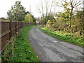
Picked Lane, Pye Corner
Picked Lane heads away west from Pye Corner.
Image: © Jaggery
Taken: 5 Nov 2009
0.02 miles
2
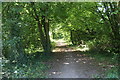
Celtic Trail in woodland
NCR 4 passes through a woodland corridor north of Hart Farm.
Image: © M J Roscoe
Taken: 30 Jul 2020
0.02 miles
3
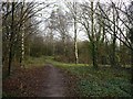
Cycle path near Pye Corner
This is National Cycle Route 4 and also the Sustrans Celtic Way East.
It is on land owned by Solutia UK Ltd http://www.geograph.org.uk/photo/556380 .
Image: © Robin Drayton
Taken: 9 Dec 2009
0.04 miles
4

Black-headed Cardinal Beetle
Found by a reen at the side of Picked Lane, Pye Corner, Newport.
Not as common as the Red-headed Cardinal Beetle www.geograph.org.uk/photo/3612479 .
Image: © Robin Drayton
Taken: 6 Jun 2015
0.04 miles
5
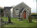
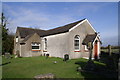
Former Nash Baptist Chapel, Pye Corner
The chapel opened in 1820 with seating for 125. Its congregation included residents of what was then the hamlet of Liswerry, a mile or so distant (about 2 kilometres).
Some of the congregation found it more convenient to attend Liswerry Baptist Church when it opened in 1889, the same year that Liswerry was incorporated into Newport under the provisions of the Newport (Mon.) Corporation Act, 1889.
This began a decline in attendances at Nash Baptist Chapel, to only 5 members in 1988. The chapel closed soon afterwards.
In 2006, a planning application was made to Newport City Council to convert the building into a dwelling house with vehicular access, but, externally at least, little has changed in the 3 years since this photo http://www.geograph.org.uk/photo/148640
Image: © Jaggery
Taken: 5 Nov 2009
0.05 miles
6
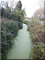
Lakes Reen, Pye Corner
Part of the Caldicot Levels drainage system, Lakes Reen is green with algae.
Image: © Jaggery
Taken: 5 Nov 2009
0.05 miles
7
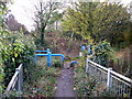
Pye Corner end of cycleway
The cycleway from Corporation Road, along the southern edge of the Solutia site, ends on reaching the edge of Pye Corner.
Image: © Jaggery
Taken: 5 Nov 2009
0.05 miles
8
Nash Baptist Chapel at Pye Corner
Only recently closed, Nash Baptist Chapel still stands in good repair. It contains a covered immersion baptismal font and a rare pedal-organ built and played (well into his nineties) by the late Mr. A. W. Haime, Master Baker (Alf to his friends) of Earlswood, Shirenewton.
Image: © Adrian and Janet Quantock
Taken: 7 Apr 2006
0.05 miles
9
Celtic Way cycle track, Pye Corner, Newport
Image: © John Lord
Taken: 30 Jan 2010
0.06 miles
10
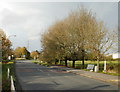
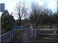
Nash Road, Pye Corner
Looking north from Pye Corner towards Meadows Road.
Image: © Jaggery
Taken: 5 Nov 2009
0.07 miles