IMAGES TAKEN NEAR TO
Straits Lane, NEWPORT, NP18 2BD
Introduction
This page details the photographs taken nearby to Straits Lane, NP18 2BD by members of the Geograph project.
The Geograph project started in 2005 with the aim of publishing, organising and preserving representative images for every square kilometre of Great Britain, Ireland and the Isle of Man.

There are currently over 7.5m images from over14,400 individuals and you can help contribute to the project by visiting https://www.geograph.org.uk
Image Map
Images are licensed for reuse under creativecommons.org/licenses/by-sa/2.0
Notes
- Clicking on the map will re-center to the selected point.
- The higher the marker number, the further away the image location is from the centre of the postcode.
Image Listing (9 Images Found)
Images are licensed for reuse under creativecommons.org/licenses/by-sa/2.0
Image
Details
Distance
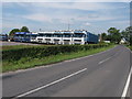
3
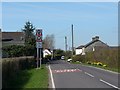
Broad Street Common
Approaching the junction with Straits Lane.
Image: © Robin Drayton
Taken: 8 Apr 2010
0.08 miles
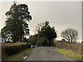
4
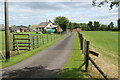
Driveway to Home Farm, Nash
Farm access road off Straits Lane.
Image: © M J Roscoe
Taken: 6 Jul 2022
0.10 miles

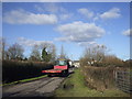
6
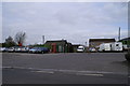
C Pike Ltd
Haulage Contractors yard
Image: © Adrian and Janet Quantock
Taken: 7 Apr 2006
0.19 miles
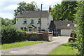
7
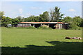
Dilapidated barn, Straits Lane
Derelict agricultural building.
Image: © M J Roscoe
Taken: 4 Aug 2021
0.21 miles