IMAGES TAKEN NEAR TO
Chapel Road, NEWPORT, NP18 2AW
Introduction
This page details the photographs taken nearby to Chapel Road, NP18 2AW by members of the Geograph project.
The Geograph project started in 2005 with the aim of publishing, organising and preserving representative images for every square kilometre of Great Britain, Ireland and the Isle of Man.

There are currently over 7.5m images from over14,400 individuals and you can help contribute to the project by visiting https://www.geograph.org.uk
Image Map
Images are licensed for reuse under creativecommons.org/licenses/by-sa/2.0
Notes
- Clicking on the map will re-center to the selected point.
- The higher the marker number, the further away the image location is from the centre of the postcode.
Image Listing (31 Images Found)
Images are licensed for reuse under creativecommons.org/licenses/by-sa/2.0
Image
Details
Distance
1
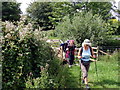
Llwybr Goldcliff / Goldcliff Path
Llwybr yn gadel heol fach yn Goldcliff.
Path leaving a minor road in Goldcliff.
Image: © Alan Richards
Taken: 10 Jul 2011
0.01 miles
2
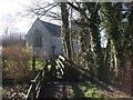
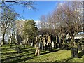
Narrow footbridge into churchyard, Goldcliff
Image: © John Lord
Taken: 30 Jan 2010
0.02 miles
3
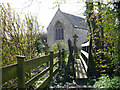
Footbridge access to the churchyard, Goldcliff
A footpath from Chapel Road gives access via this footbridge to the churchyard of St Mary Magdalene's Church at Goldcliff.
Image: © Robin Drayton
Taken: 4 Apr 2008
0.04 miles
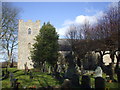
5
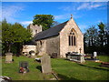
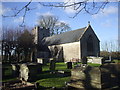
St Mary Magdalene's Church, Goldcliff
Image: © Chris Andrews
Taken: 27 Apr 2017
0.05 miles
6
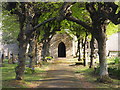
South Porch, St Mary Magdalene's, Goldcliffe
Approached under coppiced lime trees.
Image: © Chris Andrews
Taken: 27 Apr 2017
0.06 miles
10
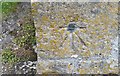
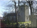
Ordnance Survey 1GL Bolt
This OS Bolt can be found on the SW angle of St Mary's Church. It marks a point 6.770m above mean sea level.
Image: © Adrian Dust
Taken: 19 May 2019
0.06 miles