IMAGES TAKEN NEAR TO
Goldcliff, NEWPORT, NP18 2AU
Introduction
This page details the photographs taken nearby to NP18 2AU by members of the Geograph project.
The Geograph project started in 2005 with the aim of publishing, organising and preserving representative images for every square kilometre of Great Britain, Ireland and the Isle of Man.

There are currently over 7.5m images from over14,400 individuals and you can help contribute to the project by visiting https://www.geograph.org.uk
Image Map
Images are licensed for reuse under creativecommons.org/licenses/by-sa/2.0
Notes
- Clicking on the map will re-center to the selected point.
- The higher the marker number, the further away the image location is from the centre of the postcode.
Image Listing (34 Images Found)
Images are licensed for reuse under creativecommons.org/licenses/by-sa/2.0
Image
Details
Distance
3
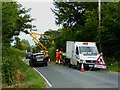
Hedge cutting action near Goldcliff
Near the junction of Goldcliff Road and Boat Road
Image: © Eirian Evans
Taken: 23 Jul 2015
0.15 miles
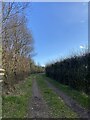
5
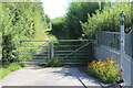
Gates on Boat Road
The Wales Coast Path, from Goldcliff Road, goes through the left gate on a restricted byway.
Image: © M J Roscoe
Taken: 14 Aug 2021
0.16 miles
6
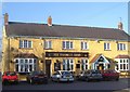
Farmers Arms, Goldcliff, Monmouthshire
Image: © Ruth Sharville
Taken: 3 Mar 2007
0.18 miles
7

St Mary Magdalene Church, Goldcliff, Gwent Levels
Church in Goldcliff. Contains a plaque commemorating the Great Flood of 1606.
Image: © Jim Mitchell
Taken: 10 Feb 2005
0.18 miles
9
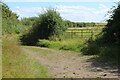
Boat Road, Newport Wetlands NNR
The Wales Coast Path goes along the lane through the Saltmarsh Grasslands towards the tidal Goldcliff Pill.
Image: © M J Roscoe
Taken: 14 Aug 2021
0.20 miles
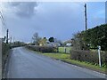
10
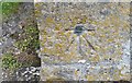
Ordnance Survey 1GL Bolt
This OS Bolt can be found on the SW angle of St Mary's Church. It marks a point 6.770m above mean sea level.
Image: © Adrian Dust
Taken: 19 May 2019
0.20 miles