IMAGES TAKEN NEAR TO
Farmfield Lane, NEWPORT, NP18 2AR
Introduction
This page details the photographs taken nearby to Farmfield Lane, NP18 2AR by members of the Geograph project.
The Geograph project started in 2005 with the aim of publishing, organising and preserving representative images for every square kilometre of Great Britain, Ireland and the Isle of Man.

There are currently over 7.5m images from over14,400 individuals and you can help contribute to the project by visiting https://www.geograph.org.uk
Image Map
Images are licensed for reuse under creativecommons.org/licenses/by-sa/2.0
Notes
- Clicking on the map will re-center to the selected point.
- The higher the marker number, the further away the image location is from the centre of the postcode.
Image Listing (52 Images Found)
Images are licensed for reuse under creativecommons.org/licenses/by-sa/2.0
Image
Details
Distance
1
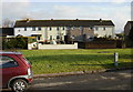
St Mary's Road houses, Nash
Houses on the east side of St Mary's Road.
Image: © Jaggery
Taken: 23 Jan 2010
0.07 miles
2
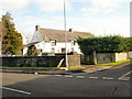
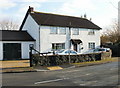
Corner Farm Cottage, Nash
The corner in question is formed by the junction of West Nash Road and Farmfield Lane.
Image: © Jaggery
Taken: 23 Jan 2010
0.09 miles
3
Gate on public footpath into field, Nash
Footpath across drive from corner in St Mary's Road.
Image: © M J Roscoe
Taken: 4 Aug 2021
0.09 miles
4
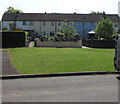
Row of houses, St Mary's Road, Nash
Set back from the east side of St Mary's Road.
Image: © Jaggery
Taken: 3 Jun 2018
0.09 miles
5
St Mary's Lodge, Nash
On the corner of West Nash Road and St Mary's Road.
Image: © Jaggery
Taken: 23 Jan 2010
0.11 miles
6
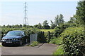
Farmfield Lane, Nash
Viewed from West Nash Road.
Image: © Jaggery
Taken: 23 Jan 2010
0.11 miles
7
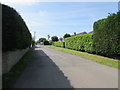
Hedge-lined Farmfield Lane, Nash
On the south side of West Nash Road.
Image: © Jaggery
Taken: 3 Jun 2018
0.11 miles
8
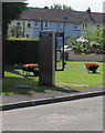
Two floral wheelbarrows, St Mary's Road, Nash
Behind an unusual type of BT phonebox. https://www.geograph.org.uk/photo/5795293
Image: © Jaggery
Taken: 3 Jun 2018
0.11 miles
9
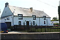
Corner Farm Cottage, Nash
House at corner of West Nash Road and Farmfield Lane.
Image: © M J Roscoe
Taken: 4 Aug 2021
0.12 miles
10
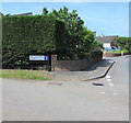
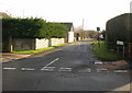
Corner of West Nash Road and Farmfield Lane, Nash
The sign shows that Farmfield Lane is Lôn Cae Fferm in Welsh. Viewed in June 2018.
A July 2012 Google Earth Street View shows an English-only name sign on this corner.
Image: © Jaggery
Taken: 3 Jun 2018
0.12 miles