IMAGES TAKEN NEAR TO
Nash, NEWPORT, NP18 2AQ
Introduction
This page details the photographs taken nearby to NP18 2AQ by members of the Geograph project.
The Geograph project started in 2005 with the aim of publishing, organising and preserving representative images for every square kilometre of Great Britain, Ireland and the Isle of Man.

There are currently over 7.5m images from over14,400 individuals and you can help contribute to the project by visiting https://www.geograph.org.uk
Image Map
Images are licensed for reuse under creativecommons.org/licenses/by-sa/2.0
Notes
- Clicking on the map will re-center to the selected point.
- The higher the marker number, the further away the image location is from the centre of the postcode.
Image Listing (18 Images Found)
Images are licensed for reuse under creativecommons.org/licenses/by-sa/2.0
Image
Details
Distance
1
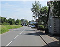
West Nash Road, Nash
Looking to the NE along West Nash Road, away from the centre of the village.
The Old Schoolhouse https://www.geograph.org.uk/photo/5795147 is on the right.
Image: © Jaggery
Taken: 3 Jun 2018
0.01 miles
2
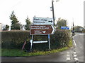
Boring Straits Lane?
The signs at the corner of Straits Lane and Nash Road suggest that all the local attractions and places of interest are elsewhere.
Image: © Jaggery
Taken: 23 Jan 2010
0.02 miles
3
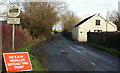
Straits Lane, Nash
Straits Lane heads away from Nash Road in the direction of Broadstreet Common.
The most plausible meaning I found for "E.A.W" on the road sign is "Electricity at Work". I rejected such Google suggestions as "Empire at War" and "European Air War".
Image: © Jaggery
Taken: 23 Jan 2010
0.02 miles
6
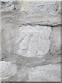
Ordnance Survey Cut Mark
This OS cut mark can be found on the NW face of the old Schoolhouse. It marks a point 6.825m above mean sea level.
Image: © Adrian Dust
Taken: 25 May 2015
0.07 miles
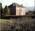
7

Old Schoolhouse, Nash
The former schoolhouse alongside West Nash Road has been converted to a five bedroom house.
Image: © Jaggery
Taken: 3 Jun 2018
0.07 miles
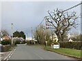
8
Morfa, Nash Road
House located on the east side of Nash Road, near the Straits Lane junction.
Image: © Jaggery
Taken: 23 Jan 2010
0.08 miles
9

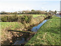
Reen near Nash, Newport
A reen beside the road approaching Nash Village. In the distance is the spire of Image .
Image: © Robin Drayton
Taken: 27 Dec 2004
0.08 miles
10
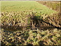
Perilous crossing plank, Windmill Reen
Windmill Reen (drainage channel) runs along the northwest edge of West Nash Road from St Mary's Road to the Goldcliff Road junction. In the lower centre of the photo, a narrow plank, covered in moss, provides a perilous method of crossing the reen.
Image: © Jaggery
Taken: 23 Jan 2010
0.09 miles