IMAGES TAKEN NEAR TO
Gilwern Farm Close, NEWPORT, NP18 1QW
Introduction
This page details the photographs taken nearby to Gilwern Farm Close, NP18 1QW by members of the Geograph project.
The Geograph project started in 2005 with the aim of publishing, organising and preserving representative images for every square kilometre of Great Britain, Ireland and the Isle of Man.

There are currently over 7.5m images from over14,400 individuals and you can help contribute to the project by visiting https://www.geograph.org.uk
Image Map
Images are licensed for reuse under creativecommons.org/licenses/by-sa/2.0
Notes
- Clicking on the map will re-center to the selected point.
- The higher the marker number, the further away the image location is from the centre of the postcode.
Image Listing (89 Images Found)
Images are licensed for reuse under creativecommons.org/licenses/by-sa/2.0
Image
Details
Distance
1

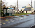
Warning sign - Patrol/Hebryngwr, Caerleon Road, Ponthir, Torfaen
English/Welsh sign alongside the B4236 on the approach to the village primary school.
The Star https://www.geograph.org.uk/photo/6680638 is in the background.
Image: © Jaggery
Taken: 19 Nov 2020
0.12 miles
2
Caerleon Road bus stop and shelter, Ponthir, Torfaen
Viewed in November 2020. This stop alongside the B4236 is for buses to Cwmbran.
The BT phonebox near the shelter in a May 2018 Google Street View has been removed.
The Star https://www.geograph.org.uk/photo/6680638 is on the right.
Image: © Jaggery
Taken: 19 Nov 2020
0.12 miles
3
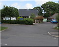
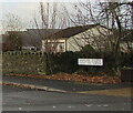
Brechfa Close, Ponthir, Torfaen
Set back from the north side of the B4236 Caerleon Road, the main road through Ponthir.
Image: © Jaggery
Taken: 22 May 2020
0.13 miles
4
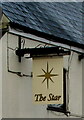
The Star name sign, Ponthir, Torfaen
Hanging from a wall bracket here. https://www.geograph.org.uk/photo/6680638
Image: © Jaggery
Taken: 19 Nov 2020
0.13 miles
5

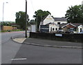
The Star, Caerleon Road, Ponthir, Torfaen
Pub alongside the B4236 viewed in November 2020.
Image: © Jaggery
Taken: 19 Nov 2020
0.13 miles
6
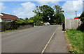
Up School Close, Ponthir, Torfaen
School Close ascends towards the B4236 Caerleon Road, the main road through Ponthir.
Image: © Jaggery
Taken: 22 May 2020
0.13 miles
7
Junction of School Close and Caerleon Road, Ponthir, Torfaen
From the right, School Close joins the B4236 Caerleon Road,
the main road through Ponthir. The Star pub is in the background.
Image: © Jaggery
Taken: 22 May 2020
0.13 miles
8
Bilingual name sign on a Ponthir corner, Torfaen
The sign on the corner of Caerleon Road shows that School Close is Clos yr Ysgol in Welsh.
Image: © Jaggery
Taken: 19 Nov 2020
0.13 miles
9

Junction of Caerleon Road and School Close, Ponthir, Torfaen
Viewed across the B4236 Caerleon Road, the main road through the village.
Image: © Jaggery
Taken: 19 Nov 2020
0.13 miles
10
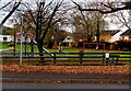
Children's play area in Ponthir, Torfaen
Set back from the south side of the B4236 Caerleon Road between the village hall and the Star pub. A small notice on the right shows NO DOGS.
Image: © Jaggery
Taken: 19 Nov 2020
0.14 miles