IMAGES TAKEN NEAR TO
New Road, NEWPORT, NP18 1QF
Introduction
This page details the photographs taken nearby to New Road, NP18 1QF by members of the Geograph project.
The Geograph project started in 2005 with the aim of publishing, organising and preserving representative images for every square kilometre of Great Britain, Ireland and the Isle of Man.

There are currently over 7.5m images from over14,400 individuals and you can help contribute to the project by visiting https://www.geograph.org.uk
Image Map
Images are licensed for reuse under creativecommons.org/licenses/by-sa/2.0
Notes
- Clicking on the map will re-center to the selected point.
- The higher the marker number, the further away the image location is from the centre of the postcode.
Image Listing (296 Images Found)
Images are licensed for reuse under creativecommons.org/licenses/by-sa/2.0
Image
Details
Distance
1
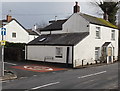
Gwent Cottage, Caerleon
On the corner of New Road and Lulworth Road in the area known as The Village, The Old Village, or Ultra Pontem.
Image: © Jaggery
Taken: 3 Jan 2014
0.00 miles
2
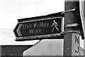
Usk Valley Walk signpost
A black and white shot of the first waymark sign we saw on our walk from Caerleon to Brecon. What the pictogram of the walker on the sign doesn't show is the enormous rucksacks full of camping kit we were both carrying.
Image: © John Winder
Taken: 22 Mar 2019
0.01 miles
4
Isca Road, Old Village, Caerleon
Isca Road heads away from New Road. On the left is the Ship Inn http://www.geograph.org.uk/photo/1591134. Isca (a Latinized form of 'Usk' ) was the Roman name for Caerleon.
Image: © Jaggery
Taken: 23 Aug 2009
0.01 miles
5
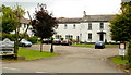
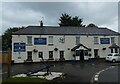
The Malthouse Hotel, New Road
The hotel is located on the Newport side of the River Usk , in the area known as Ultra Pontem or The (Old) Village.
The premises were built in 1837 as Lulworth House, a property that had a malthouse and other outbuildings. From about 1880 to 1920, it was in use as Lulworth House Preparatory School.
Image: © Jaggery
Taken: 23 Aug 2009
0.01 miles
6
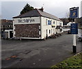
The Ship Inn, Caerleon
Pub, restaurant and B&B accommodation located on the corner of New Road and Lulworth Road on the south bank of the River Usk, in the area known as The Village, The Old Village, or Ultra Pontem.
The Ship Inn was built c1820, at the same time as the construction of a toll road to Newport.
Here's http://www.geograph.org.uk/photo/1591134 how the inn was in 2009.
Image: © Jaggery
Taken: 3 Jan 2014
0.01 miles
7
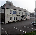
Ship Inn in thinning fog, Caerleon
Thick fog is clearing at 10:18am on October 19th 2018 during a period of anticyclonic weather. The Ship Inn pub, restaurant and B&B accommodation is located on the corner of New Road and Lulworth Road on the south bank of the River Usk, in the area known as The Village, The Old Village, or Ultra Pontem. The Ship Inn was built c1820, at the same time as the construction of a toll road to Newport.
Image: © Jaggery
Taken: 19 Oct 2018
0.01 miles
8
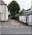
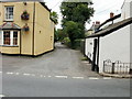
20 on one-way Lulworth Road, Caerleon
The 30mph speed limit on New Road drops to 20mph. Ahead for Isca Road and Bulmore Road.
Image: © Jaggery
Taken: 13 Jul 2020
0.01 miles
9
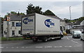
Truline lorry in Caerleon
Entering New Road towards Christchurch in July 2020. Text on the lorry includes "Delivering for business".
Image: © Jaggery
Taken: 13 Jul 2020
0.01 miles
10
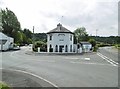
Former Tollhouse by the B4236,
Caerleon Toll House by the B4236, in parish of CAERLEON (Newport District), Toll Gate House, New Road, opposite The "Ship inn" PH close to bridge, junction with Lulworth Road, NP18 1QB.
Grade II listed by Cadw.
Reference Number: 2991 https://cadwpublic-api.azurewebsites.net/reports/listedbuilding/FullReport?lang=&id=2991
To be surveyed
Milestone Society National ID: NEW.CAE
Image: © Milestone Society
Taken: Unknown
0.02 miles