IMAGES TAKEN NEAR TO
Lulworth Road, NEWPORT, NP18 1QE
Introduction
This page details the photographs taken nearby to Lulworth Road, NP18 1QE by members of the Geograph project.
The Geograph project started in 2005 with the aim of publishing, organising and preserving representative images for every square kilometre of Great Britain, Ireland and the Isle of Man.

There are currently over 7.5m images from over14,400 individuals and you can help contribute to the project by visiting https://www.geograph.org.uk
Image Map
Images are licensed for reuse under creativecommons.org/licenses/by-sa/2.0
Notes
- Clicking on the map will re-center to the selected point.
- The higher the marker number, the further away the image location is from the centre of the postcode.
Image Listing (295 Images Found)
Images are licensed for reuse under creativecommons.org/licenses/by-sa/2.0
Image
Details
Distance
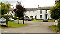
1
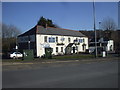
Former Malthouse Hotel, Caerleon
An early January 2014 view across New Road in the area known as The Village, The Old Village, or Ultra Pontem. On a nearby lamppost, a planning notice dated December 30th 2013 announces the proposed change of use from hotel to residential dwelling.
Image: © Jaggery
Taken: 3 Jan 2014
0.02 miles
2

Former White Lion House, Caerleon
The former White Lion House was a 17th century serving the eastern end of an old wooden bridge over the River Usk at Caerleon.
Image: © Philip Halling
Taken: 11 Apr 2009
0.03 miles
3
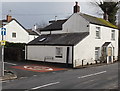
Gwent Cottage, Caerleon
On the corner of New Road and Lulworth Road in the area known as The Village, The Old Village, or Ultra Pontem.
Image: © Jaggery
Taken: 3 Jan 2014
0.03 miles
4
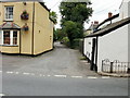
Isca Road, Old Village, Caerleon
Isca Road heads away from New Road. On the left is the Ship Inn http://www.geograph.org.uk/photo/1591134. Isca (a Latinized form of 'Usk' ) was the Roman name for Caerleon.
Image: © Jaggery
Taken: 23 Aug 2009
0.04 miles
5
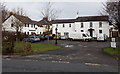
The Malthouse Hotel, New Road
The hotel is located on the Newport side of the River Usk , in the area known as Ultra Pontem or The (Old) Village.
The premises were built in 1837 as Lulworth House, a property that had a malthouse and other outbuildings. From about 1880 to 1920, it was in use as Lulworth House Preparatory School.
Image: © Jaggery
Taken: 23 Aug 2009
0.04 miles
6
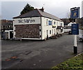
The Ship Inn, Caerleon
Pub, restaurant and B&B accommodation located on the corner of New Road and Lulworth Road on the south bank of the River Usk, in the area known as The Village, The Old Village, or Ultra Pontem.
The Ship Inn was built c1820, at the same time as the construction of a toll road to Newport.
Here's http://www.geograph.org.uk/photo/1591134 how the inn was in 2009.
Image: © Jaggery
Taken: 3 Jan 2014
0.04 miles
7
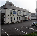
Ship Inn in thinning fog, Caerleon
Thick fog is clearing at 10:18am on October 19th 2018 during a period of anticyclonic weather. The Ship Inn pub, restaurant and B&B accommodation is located on the corner of New Road and Lulworth Road on the south bank of the River Usk, in the area known as The Village, The Old Village, or Ultra Pontem. The Ship Inn was built c1820, at the same time as the construction of a toll road to Newport.
Image: © Jaggery
Taken: 19 Oct 2018
0.04 miles
8
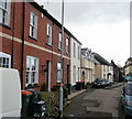
Isca Road, The Old Village
The street runs alongside the River Usk, on its south bank.
To outsiders, this is Caerleon, but locals insist they are not part of Caerleon.
Instead, they refer to this area as The Village, The Old Village, or Ultra Pontem
(beyond the bridge).
Image: © Jaggery
Taken: 28 Feb 2010
0.04 miles
9
Isca Road, Caerleon
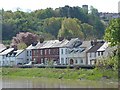
This is the area of Caerleon that is on the other side of the River Usk from the main town.
It is known as The Village or Ultra Pontem.
Viewed from the Millennium Garden http://www.geograph.org.uk/photo/1288884 .
Image: © Robin Drayton
Taken: 29 Apr 2009
0.04 miles