IMAGES TAKEN NEAR TO
Caerleon Road, NEWPORT, NP18 1QA
Introduction
This page details the photographs taken nearby to Caerleon Road, NP18 1QA by members of the Geograph project.
The Geograph project started in 2005 with the aim of publishing, organising and preserving representative images for every square kilometre of Great Britain, Ireland and the Isle of Man.

There are currently over 7.5m images from over14,400 individuals and you can help contribute to the project by visiting https://www.geograph.org.uk
Image Map
Images are licensed for reuse under creativecommons.org/licenses/by-sa/2.0
Notes
- Clicking on the map will re-center to the selected point.
- The higher the marker number, the further away the image location is from the centre of the postcode.
Image Listing (44 Images Found)
Images are licensed for reuse under creativecommons.org/licenses/by-sa/2.0
Image
Details
Distance
1
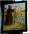
St Julian name sign, Newport
On the right here. http://www.geograph.org.uk/photo/4874131 The pub website states that the pub is named after Saint Julian the Hospitaller.
Saint Julian is a popular saint in Western Europe. According to the legend, he was a nobleman who through a mistake of identity killed his own father and mother. As penance, he and his wife travelled to Rome as pilgrims seeking absolution.
On his way home he went with his wife to live near a river ford (depicted here) where they gave help to travellers, building a refuge to care for the poor and sick and rowing travellers across the river for free.
At various times, Julian has been honoured as the Patron Saint of innkeepers, hospitallers, pilgrims, ferrymen, boatmen, fiddlers and wandering musicians. St Julian is thus an ideal choice for a pub name.
Image: © Jaggery
Taken: 22 Mar 2016
0.01 miles
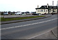
2
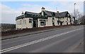
The St Julians, Newport
Viewed across the B4596 Caerleon Road, the main road from Newport to Caerleon.
The St Julians pub is in a semi-rural location, above the south bank of the River Usk.
http://www.geograph.org.uk/photo/4874154 to a view of the name sign on the right and some information about Saint Julian.
Image: © Jaggery
Taken: 22 Mar 2016
0.01 miles
3
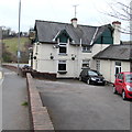
East side of the St Julians, Newport
The St Julians pub is alongside the B4596 Caerleon Road, above the south bank of the River Usk.
http://www.geograph.org.uk/photo/4874154 to a view of the name sign on the left and some information about Saint Julian.
http://www.geograph.org.uk/photo/4874131 to another view of the pub.
Image: © Jaggery
Taken: 22 Mar 2016
0.01 miles
5
Roadside daffodils, Caerleon Road, Newport
Viewed across the B4596 Caerleon Road on March 22nd 2016.
Image: © Jaggery
Taken: 22 Mar 2016
0.02 miles
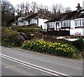
6
Daffodils and bungalows, Caerleon Road, Newport
Viewed in March 2016. The St Julians http://www.geograph.org.uk/photo/4874131 is nearby.
Image: © Jaggery
Taken: 22 Mar 2016
0.02 miles
7
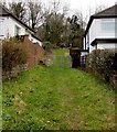
Track into St Julian's Park, Newport
From the east side of Caerleon Road. The dark green notice behind the gate shows
MOTOR VEHICLES PROHIBITED.
Image: © Jaggery
Taken: 22 Mar 2016
0.03 miles
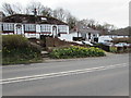
8
The St Julians car park, Caerleon Road, Newport
Located between the B4596 Caerleon Road and the River Usk, on the west side of the St Julians pub. http://www.geograph.org.uk/photo/1770185
Image: © Jaggery
Taken: 22 Mar 2016
0.03 miles
9
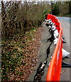
Cracked surface, Caerleon Road, Newport
In late March 2016, temporary barriers fence off a cracked
section of the B4596 Caerleon Road on a bank above the River Usk.
Image: © Jaggery
Taken: 22 Mar 2016
0.04 miles
10

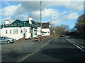
Speed camera sign, Caerleon Road, Newport
Alongside the B4596 Caerleon Road on the eastern approach to the St Julians. http://www.geograph.org.uk/photo/4874131
Temporary fencing is in front of a crack in the road surface.
Image: © Jaggery
Taken: 22 Mar 2016
0.04 miles