IMAGES TAKEN NEAR TO
Westgate Court, NEWPORT, NP18 1NA
Introduction
This page details the photographs taken nearby to Westgate Court, NP18 1NA by members of the Geograph project.
The Geograph project started in 2005 with the aim of publishing, organising and preserving representative images for every square kilometre of Great Britain, Ireland and the Isle of Man.

There are currently over 7.5m images from over14,400 individuals and you can help contribute to the project by visiting https://www.geograph.org.uk
Image Map
Images are licensed for reuse under creativecommons.org/licenses/by-sa/2.0
Notes
- Clicking on the map will re-center to the selected point.
- The higher the marker number, the further away the image location is from the centre of the postcode.
Image Listing (466 Images Found)
Images are licensed for reuse under creativecommons.org/licenses/by-sa/2.0
Image
Details
Distance
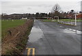
1
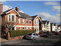
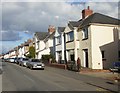
Lodge Road houses, Caerleon
Houses on the east side of Lodge Road, opposite Westgate Court.
Image: © Jaggery
Taken: 14 Mar 2010
0.01 miles
2
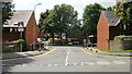
Westgate Court, Caerleon
Lodge Road entrance to Westgate Court, an area of sheltered housing built in 1964, now managed by Newport City Homes.
Image: © Jaggery
Taken: 27 Aug 2009
0.01 miles
3
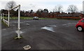
Car park opposite Caerleon AFC's ground
Located opposite Caerleon football club's home ground. The metal frame resembling a football goalpost is intended to prevent high vehicles (such as lorries) from parking here, but any overheight vehicle could enter through the gap near the camera. There was no gap here several years ago.
Image: © Jaggery
Taken: 3 Jan 2014
0.04 miles
4
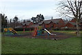
Children's play area near Cold Bath Road, Caerleon
A notice at the entrance states that this is a Newport City Council play facility
designed for children aged 3-9 years. Supervision of young children is advisable.
Image: © Jaggery
Taken: 3 Jan 2014
0.04 miles
5
Broadwalk, Caerleon
Houses on the east side of Broadwalk, viewed from the corner of Lodge Road.
Image: © Jaggery
Taken: 14 Mar 2010
0.05 miles
6
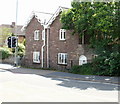
Stone Cottage, Caerleon
A stone cottage named Stone Cottage, on the corner of Lodge Road and Cold Bath Road.
Image: © Jaggery
Taken: 27 Aug 2009
0.05 miles
7
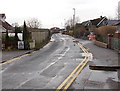
Cold Bath Road, Caerleon
This is the road to Caerleon Comprehensive School, viewed from near the corner of Lodge Road.
The road's name is a reference to the nearby remains of a frigidarium in an Ancient Roman baths site.
The frigidarium was the room inside the baths with a cold bathing pool.
There were also the tepidarium (warm baths) and caldarium (hot baths).
Image: © Jaggery
Taken: 3 Jan 2014
0.05 miles
8
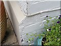
Ordnance Survey Cut Mark
This OS cut mark can be found on No3 Lodge Road. It marks a point 20.280m above mean sea level.
Image: © Adrian Dust
Taken: 17 Jun 2018
0.05 miles
9
Puddles in early January, Caerleon
On an unnamed side road near Cold Bath Road.
Image: © Jaggery
Taken: 3 Jan 2014
0.06 miles
10
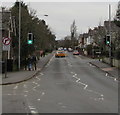
Pelican crossing, Lodge Road, Caerleon
Chambers Dictionary states that pelican in this context is adapted from "pedestrian light controlled crossing".
Image: © Jaggery
Taken: 31 Dec 2018
0.06 miles