IMAGES TAKEN NEAR TO
Llew A Dor Cwrt, NEWPORT, NP18 1LG
Introduction
This page details the photographs taken nearby to Llew A Dor Cwrt, NP18 1LG by members of the Geograph project.
The Geograph project started in 2005 with the aim of publishing, organising and preserving representative images for every square kilometre of Great Britain, Ireland and the Isle of Man.

There are currently over 7.5m images from over14,400 individuals and you can help contribute to the project by visiting https://www.geograph.org.uk
Image Map
Images are licensed for reuse under creativecommons.org/licenses/by-sa/2.0
Notes
- Clicking on the map will re-center to the selected point.
- The higher the marker number, the further away the image location is from the centre of the postcode.
Image Listing (512 Images Found)
Images are licensed for reuse under creativecommons.org/licenses/by-sa/2.0
Image
Details
Distance
1
Tram Road, Caerleon
Viewed from the edge of Mill Street. Trams (or tram roads or tram lanes) were roads with wooden, stone, or metal wheel-tracks, originally in or from a coal mine, later used more widely.
Once common in SE Wales, nowadays the street name is often the only remaining evidence of a tram.
Image: © Jaggery
Taken: 3 Jan 2014
0.02 miles
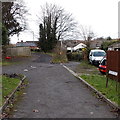
2
Broadwell Court, Caerleon
Viewed from the Mill Street end looking towards a part of Broadwell Court built over the roadway.
Image: © Jaggery
Taken: 3 Jan 2014
0.02 miles
3
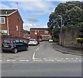
On-street parking, Broadwell Court, Caerleon
Cars are parked in a dead-end street on the NE side of the B4236 Mill Street in March 2022.
Image: © Jaggery
Taken: 17 Mar 2022
0.02 miles
4
Police Station direction sign, Mill Street, Caerleon
The sign shows that Police Station is Orsaf Heddlu in Welsh.
Image: © Jaggery
Taken: 26 Jul 2019
0.03 miles
5
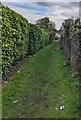
Grassy track, Caerleon
On the southeast side of Usk Road.
Image: © Jaggery
Taken: 17 Mar 2022
0.04 miles
6
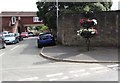
Caerleon in Bloom, Broadwell Court, Caerleon
The floral display is sponsored by Chris Spiteri Recovery Services.
Image: © Jaggery
Taken: 26 Jul 2019
0.04 miles
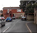
7
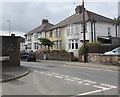
Mill Street semis, Caerleon
Four semi-detached houses viewed from the corner of Broadwell Court.
Image: © Jaggery
Taken: 26 Jul 2019
0.04 miles
8
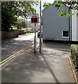
Your Speed indicator, Mill Street, Caerleon
Facing the B4236 Mill Street on the approach to the Norman Street junction. Usually off, the display turns on to show the speed in green if an approaching vehicle is within the speed limit, or red if over the speed limit, as now.
Image: © Jaggery
Taken: 26 Jul 2019
0.04 miles
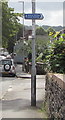
9
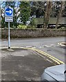
Unffordd / One way sign facing Norman Street, Caerleon
Welsh/English sign at the B4236 Mill Street junction.
Image: © Jaggery
Taken: 17 Mar 2022
0.04 miles
10
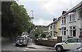
Mill Street houses, Caerleon
This part of Mill Street is between Sainsbury's Local and Norman Street.
Image: © Jaggery
Taken: 26 Jul 2019
0.04 miles