IMAGES TAKEN NEAR TO
Kemeys Inferior, NEWPORT, NP18 1JS
Introduction
This page details the photographs taken nearby to NP18 1JS by members of the Geograph project.
The Geograph project started in 2005 with the aim of publishing, organising and preserving representative images for every square kilometre of Great Britain, Ireland and the Isle of Man.

There are currently over 7.5m images from over14,400 individuals and you can help contribute to the project by visiting https://www.geograph.org.uk
Image Map
Images are licensed for reuse under creativecommons.org/licenses/by-sa/2.0
Notes
- Clicking on the map will re-center to the selected point.
- The higher the marker number, the further away the image location is from the centre of the postcode.
Image Listing (9 Images Found)
Images are licensed for reuse under creativecommons.org/licenses/by-sa/2.0
Image
Details
Distance
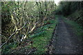
1
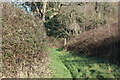
Footpath meets bridleway at waymarker
The Usk Valley Walk joins a hillside bridleway and turns right uphill.
Image: © M J Roscoe
Taken: 7 Feb 2023
0.06 miles
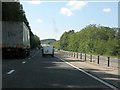
3
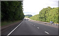
A449 straight along the Usk valley
The road follows this river for some miles. It is just behind the trees on the right.
Image: © Julian P Guffogg
Taken: 9 Aug 2013
0.10 miles
4
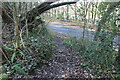
Junction of bridleway and Bulmore Road
The bridleway goes uphill behind the camera to Kemeys Graig.
Image: © M J Roscoe
Taken: 7 Feb 2023
0.10 miles
6
Meander in the River Usk, from above the A449
Image: © Ruth Sharville
Taken: 17 Jan 2009
0.18 miles
7
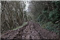
Logging on the Usk Valley Walk
The route of the Usk Valley Walk had been used as access for logging vehicles not long before we walked it. There was perhaps a mile and a half of this and it made for extremely difficult walking, especially when laden with camping gear!
Image: © John Winder
Taken: 22 Mar 2019
0.21 miles
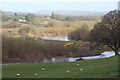
9

Rural scene, River Usk
From the vantage point of the minor road above the A449 can be seen pastureland in the foreground, the meandering River Usk, and an expanse of arable land on the hillside beyond.
Image: © Ruth Sharville
Taken: 17 Jan 2009
0.24 miles