IMAGES TAKEN NEAR TO
Catsash, NEWPORT, NP18 1JQ
Introduction
This page details the photographs taken nearby to NP18 1JQ by members of the Geograph project.
The Geograph project started in 2005 with the aim of publishing, organising and preserving representative images for every square kilometre of Great Britain, Ireland and the Isle of Man.

There are currently over 7.5m images from over14,400 individuals and you can help contribute to the project by visiting https://www.geograph.org.uk
Image Map
Images are licensed for reuse under creativecommons.org/licenses/by-sa/2.0
Notes
- Clicking on the map will re-center to the selected point.
- The higher the marker number, the further away the image location is from the centre of the postcode.
Image Listing (28 Images Found)
Images are licensed for reuse under creativecommons.org/licenses/by-sa/2.0
Image
Details
Distance
1
Westernmost part of golf course
Course near the A449.
Image: © M J Roscoe
Taken: 7 Feb 2023
0.05 miles
2
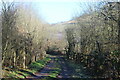
Track to pumping station, near A449
Public footpath to Abernant Farm.
Image: © M J Roscoe
Taken: 7 Feb 2023
0.07 miles
3
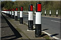
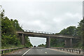
Road bollards, Cat's Ash
Road bollards on a bridge over the A449 at Cat's Ash.
Image: © Philip Halling
Taken: 11 Apr 2009
0.08 miles
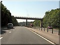
4
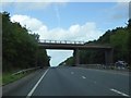
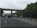
Cat's Ash (or Catsash) Bridge over A449
The main road runs through a cutting here
Image: © David Smith
Taken: 29 Sep 2016
0.08 miles
7
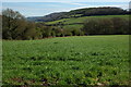
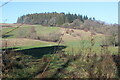
Wentwood Hill
The wooded Wentworth Hill is situated between the Usk valley and the Severn estuary.
Image: © Philip Halling
Taken: 11 Apr 2009
0.09 miles
9

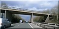
A449 from Cat's Ash Bridge
This is the main road from Newport to Monmouth.
Image: © Ruth Sharville
Taken: 10 Mar 2007
0.10 miles