IMAGES TAKEN NEAR TO
Old Hill, NEWPORT, NP18 1JG
Introduction
This page details the photographs taken nearby to Old Hill, NP18 1JG by members of the Geograph project.
The Geograph project started in 2005 with the aim of publishing, organising and preserving representative images for every square kilometre of Great Britain, Ireland and the Isle of Man.

There are currently over 7.5m images from over14,400 individuals and you can help contribute to the project by visiting https://www.geograph.org.uk
Image Map
Images are licensed for reuse under creativecommons.org/licenses/by-sa/2.0
Notes
- Clicking on the map will re-center to the selected point.
- The higher the marker number, the further away the image location is from the centre of the postcode.
Image Listing (62 Images Found)
Images are licensed for reuse under creativecommons.org/licenses/by-sa/2.0
Image
Details
Distance
1
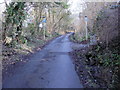
Steep middle section, Old Hill, Christchurch
The incline gets steeper along the middle section of Old Hill as it climbs towards
the summit of Christchurch. But the steepest section lies ahead... http://www.geograph.org.uk/photo/1772476
Image: © Jaggery
Taken: 21 Feb 2010
0.05 miles
2
Steepest section of Old Hill, Christchurch
Just when the walker's weary legs have almost reached the limit of their endurance, Old Hill's gradient steepens yet again as it approaches the summit of Christchurch.
Image: © Jaggery
Taken: 21 Feb 2010
0.09 miles
3
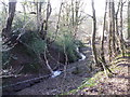
Stream, Old Hill, Christchurch
A stream runs alongside the western edge of Old Hill.
Image: © Jaggery
Taken: 21 Feb 2010
0.11 miles
4
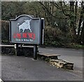
Los Reyes Tapas & Wine Bar nameboard, Belmont Hill, Caerleon
Located near a bull statue https://www.geograph.org.uk/photo/7440888 outside Los Reyes Tapas & Wine Bar.
Image: © Jaggery
Taken: 26 Mar 2023
0.11 miles
5

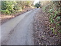
The bottom of Old Hill, Christchurch
Viewed from the B4236 (at the bottom of Belmont Hill). This lower section of Old Hill is fairly gentle, in contrast to the steep, http://www.geograph.org.uk/photo/1772468 and very steep, http://www.geograph.org.uk/photo/1772476 sections that lie ahead.
Image: © Jaggery
Taken: 21 Feb 2010
0.11 miles
6
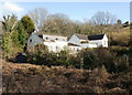
Houses at the foot of Old Hill, Christchurch
Viewed from a path connecting Bulmore Road with the edge of St Julians Wood.
Image: © Jaggery
Taken: 21 Feb 2010
0.11 miles
7
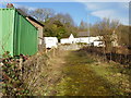
Path from St Julians Wood to Bulmore Road
Viewed from near the septic tank enclosure, http://www.geograph.org.uk/photo/1772420 a path heads towards its end at Bulmore Road.
Image: © Jaggery
Taken: 21 Feb 2010
0.11 miles
8
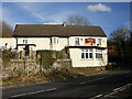
Spice Corner At The Kings Arms, Belmont Hill
Located roughly half way between Caerleon and Christchurch, on the corner of Belmont Hill and Old Hill. Formerly the Kings Arms pub, now an Indian restaurant.
Image: © Jaggery
Taken: 21 Feb 2010
0.11 miles
9
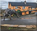
Bull statue, Belmont Hill, Caerleon
Outside Los Reyes Tapas & Wine Bar viewed in March 2023. "Los Reyes" is
Spanish for "The Kings". Many years ago, the building in the background
was the Kings Arms pub.
Image: © Jaggery
Taken: 26 Mar 2023
0.11 miles
10
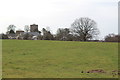
Across fields towards Christchurch
Viewed from Catsash Road with the tower of Holy Trinity Church on the skyline.
Image: © M J Roscoe
Taken: 23 Mar 2018
0.14 miles