IMAGES TAKEN NEAR TO
Caerleon Road, NEWPORT, NP18 1GX
Introduction
This page details the photographs taken nearby to Caerleon Road, NP18 1GX by members of the Geograph project.
The Geograph project started in 2005 with the aim of publishing, organising and preserving representative images for every square kilometre of Great Britain, Ireland and the Isle of Man.

There are currently over 7.5m images from over14,400 individuals and you can help contribute to the project by visiting https://www.geograph.org.uk
Image Map
Images are licensed for reuse under creativecommons.org/licenses/by-sa/2.0
Notes
- Clicking on the map will re-center to the selected point.
- The higher the marker number, the further away the image location is from the centre of the postcode.
Image Listing (124 Images Found)
Images are licensed for reuse under creativecommons.org/licenses/by-sa/2.0
Image
Details
Distance
1
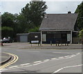
Derelict former Park Stores on a Ponthir corner, Torfaen
Derelict shop on the corner of the B4236 Caerleon Road and Station Road viewed in May 2020.
This https://www.geograph.org.uk/photo/1769127 October 2009 photo shows Park Stores open for business.
Image: © Jaggery
Taken: 22 May 2020
0.02 miles
2
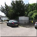
Ponthir electricity substation, Torfaen
Western Power Distribution electricity substation in a locked enclosure set back from Station Road.
Image: © Jaggery
Taken: 22 May 2020
0.02 miles
3
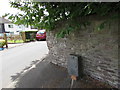
Bonar Long transformer box, Station Road, Ponthir, Torfaen
Located near Ponthir electricity substation https://www.geograph.org.uk/photo/6482999 viewed in May 2020.
Now defunct, transformer manufacturer Bonar Long was established in Dundee in 1936.
Image: © Jaggery
Taken: 22 May 2020
0.02 miles
4
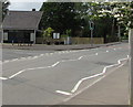
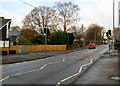
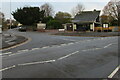
Zigzag white markings on Caerleon Road, Ponthir, Torfaen
Marking the Keep Clear Zone near a pelican crossing.
The Station Road junction is on the left.
Image: © Jaggery
Taken: 22 May 2020
0.02 miles
5
Caerleon Road pelican crossing, Ponthir, Torfaen
Across the B4236 Caerleon Road near the Station Road junction. Chambers Dictionary states that pelican in this context is adapted from "pedestrian light controlled crossing".
Image: © Jaggery
Taken: 19 Nov 2020
0.02 miles
6
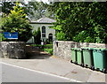
Wheelie bins at the entrance to Zion Baptist Church, Ponthir, Torfaen
Viewed across Station Road. The late Georgian church https://www.geograph.org.uk/photo/6483919 is Grade II Listed.
Image: © Jaggery
Taken: 22 May 2020
0.03 miles
7
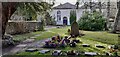
Memorials, Zion Baptist Chapel, Ponthir
Zion Baptist Chapel, built in 1803 and modified in 1834 is Grade II listed as a late Georgian chapel and schoolroom with an unusual broad double facade.
The memorials and graves in the surrounding grounds span the 200+ years of its existence.
Image: © Robin Drayton
Taken: 21 Feb 2022
0.03 miles
8

Private road to the village hall car park, Ponthir, Torfaen
From the B4236, the main road through the village.
The kegs on the right are outside the village hall. https://www.geograph.org.uk/photo/6680614
Image: © Jaggery
Taken: 19 Nov 2020
0.03 miles
9
Station Road, Ponthir, Torfaen
Viewed across the B4236 Caerleon Road in May 2020. The sign on the right shows that STATION ROAD is HEOL YR ORSAF in Welsh. Station Road formerly led to Ponthir railway station where passenger services ended in 1962.
Image: © Jaggery
Taken: 22 May 2020
0.03 miles
10
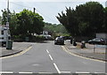
Junction of Caerleon Road and Station Road, Ponthir, Torfaen
Viewed across the B4236 Caerleon Road in November 2020. Station Road formerly led to Ponthir railway station where passenger services ended in 1962.
Image: © Jaggery
Taken: 19 Nov 2020
0.03 miles