IMAGES TAKEN NEAR TO
Oaklands, NEWPORT, NP18 1GS
Introduction
This page details the photographs taken nearby to Oaklands, NP18 1GS by members of the Geograph project.
The Geograph project started in 2005 with the aim of publishing, organising and preserving representative images for every square kilometre of Great Britain, Ireland and the Isle of Man.

There are currently over 7.5m images from over14,400 individuals and you can help contribute to the project by visiting https://www.geograph.org.uk
Image Map
Images are licensed for reuse under creativecommons.org/licenses/by-sa/2.0
Notes
- Clicking on the map will re-center to the selected point.
- The higher the marker number, the further away the image location is from the centre of the postcode.
Image Listing (103 Images Found)
Images are licensed for reuse under creativecommons.org/licenses/by-sa/2.0
Image
Details
Distance
1
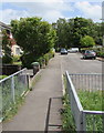
Pavement towards Oaklands, Ponthir, Torfaen
Looking east from near an entrance to the village's sports ground. https://www.geograph.org.uk/photo/6488165
Image: © Jaggery
Taken: 22 May 2020
0.01 miles
2
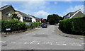
Oaklands, Ponthir, Torfaen
Viewed from Station Road looking north along the cul-de-sac Oaklands.
The sign on the left shows that Oaklands is Tir y Deri in Welsh.
Image: © Jaggery
Taken: 22 May 2020
0.01 miles
3
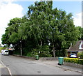
Shades of green, Oaklands, Ponthir, Torfaen
The Torfaen County Borough Council wheelie bin on the right is
a different shade of green from the one below an area of trees.
Image: © Jaggery
Taken: 22 May 2020
0.02 miles
4
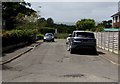
Towards the village sports ground, Ponthir, Torfaen
From Oaklands towards the east side of the village sports ground.
Image: © Jaggery
Taken: 22 May 2020
0.03 miles
5

Entrance to the east side of the village sports ground, Ponthir, Torfaen
From Oaklands.
Image: © Jaggery
Taken: 22 May 2020
0.03 miles
6
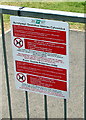
Public Spaces Protection Order notice, Ponthir, Torfaen
In the background on the left here https://www.geograph.org.uk/photo/6488165 at an entrance to the village sports ground. The text is in English and Welsh.
Image: © Jaggery
Taken: 22 May 2020
0.03 miles
7
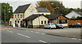
The Star Inn and Seren Restaurant, Ponthir
Pub with attached restaurant, Caerleon Road.
Image: © Jaggery
Taken: 15 Oct 2009
0.03 miles
8
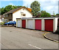
Five lockup garages, Oaklands, Ponthir, Torfaen
Oaklands is a long cul-de-sac on the north side of Station Road.
Image: © Jaggery
Taken: 22 May 2020
0.03 miles
9
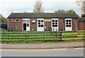
Ponthir Village Hall
Located on the south side of Caerleon Road. The hall is used by a wide variety of local groups and societies, including modern ballroom dancing, karate, bridge, bowls and tae kwando.
Image: © Jaggery
Taken: 29 Oct 2009
0.04 miles
10
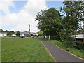
Path past the eastern edge of the village sports ground, Ponthir, Torfaen
Ahead for School Close leading to the B4236 Caerleon Road, the main road through the village.
Image: © Jaggery
Taken: 22 May 2020
0.04 miles