IMAGES TAKEN NEAR TO
Station Road, NEWPORT, NP18 1GQ
Introduction
This page details the photographs taken nearby to Station Road, NP18 1GQ by members of the Geograph project.
The Geograph project started in 2005 with the aim of publishing, organising and preserving representative images for every square kilometre of Great Britain, Ireland and the Isle of Man.

There are currently over 7.5m images from over14,400 individuals and you can help contribute to the project by visiting https://www.geograph.org.uk
Image Map
Images are licensed for reuse under creativecommons.org/licenses/by-sa/2.0
Notes
- Clicking on the map will re-center to the selected point.
- The higher the marker number, the further away the image location is from the centre of the postcode.
Image Listing (100 Images Found)
Images are licensed for reuse under creativecommons.org/licenses/by-sa/2.0
Image
Details
Distance
1
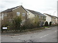
Oaklands, Ponthir
Houses on Oaklands, near the corner of Station Road.
Image: © Jaggery
Taken: 25 Mar 2010
0.02 miles
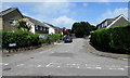
2
Junction of Station Road and Oaklands, Ponthir, Torfaen
The sign on the right shows that Oaklands is Tir y Deri in Welsh. Station Road is a dead end ahead. The trees on the left are at the edge of the Welsh Marches Line railway near the site of Ponthir station where passenger services ended in 1962.
Image: © Jaggery
Taken: 22 May 2020
0.02 miles
3
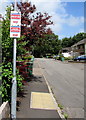
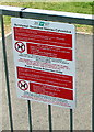
Cold Calling Control Zone notice, Oaklands, Ponthir, Torfaen
The Trading Standards notice is near the car here. https://www.geograph.org.uk/photo/6487834 The text is in English and Welsh. Cold calling is the contacting by businesses or their agents of people thought to be potential customers, without the contact having been prearranged.
Image: © Jaggery
Taken: 22 May 2020
0.02 miles
4
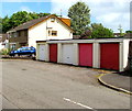
Five lockup garages, Oaklands, Ponthir, Torfaen
Oaklands is a long cul-de-sac on the north side of Station Road.
Image: © Jaggery
Taken: 22 May 2020
0.03 miles
5
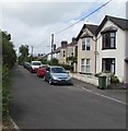
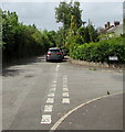
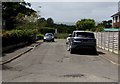
Station Road houses and cars, Ponthir, Torfaen
This part of Station Road is between the Hafod Road junction and the Oaklands junction.
Image: © Jaggery
Taken: 22 May 2020
0.03 miles
6
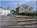
Level crossing, Ponthir
The station house, on the right, is all that remains of the former GWR railway station.
Image: © Roger Cornfoot
Taken: 11 Apr 2007
0.03 miles
7
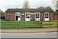
Ponthir Village Hall
Located on the south side of Caerleon Road. The hall is used by a wide variety of local groups and societies, including modern ballroom dancing, karate, bridge, bowls and tae kwando.
Image: © Jaggery
Taken: 29 Oct 2009
0.04 miles
8
Oaklands, Ponthir, Torfaen
Viewed from Station Road looking north along the cul-de-sac Oaklands.
The sign on the left shows that Oaklands is Tir y Deri in Welsh.
Image: © Jaggery
Taken: 22 May 2020
0.04 miles
9
Public Spaces Protection Order notice, Ponthir, Torfaen
In the background on the left here https://www.geograph.org.uk/photo/6488165 at an entrance to the village sports ground. The text is in English and Welsh.
Image: © Jaggery
Taken: 22 May 2020
0.04 miles
10
Towards the village sports ground, Ponthir, Torfaen
From Oaklands towards the east side of the village sports ground.
Image: © Jaggery
Taken: 22 May 2020
0.04 miles