IMAGES TAKEN NEAR TO
Moyle Grove, NEWPORT, NP18 1GP
Introduction
This page details the photographs taken nearby to Moyle Grove, NP18 1GP by members of the Geograph project.
The Geograph project started in 2005 with the aim of publishing, organising and preserving representative images for every square kilometre of Great Britain, Ireland and the Isle of Man.

There are currently over 7.5m images from over14,400 individuals and you can help contribute to the project by visiting https://www.geograph.org.uk
Image Map
Images are licensed for reuse under creativecommons.org/licenses/by-sa/2.0
Notes
- Clicking on the map will re-center to the selected point.
- The higher the marker number, the further away the image location is from the centre of the postcode.
Image Listing (132 Images Found)
Images are licensed for reuse under creativecommons.org/licenses/by-sa/2.0
Image
Details
Distance
1
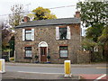
Pen-y-Brenin, Ponthir
Stone-built house located on Caerleon Road, opposite Candwr Park.
Image: © Jaggery
Taken: 29 Oct 2009
0.04 miles
2
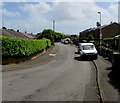
Hafod Road, Ponthir, Torfaen
Viewed from the corner of Station Road. The Welsh Marches Line railway is behind the houses on the right.
Image: © Jaggery
Taken: 22 May 2020
0.05 miles
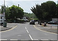
3
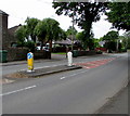
Caerleon Road pedestrian refuge, Ponthir, Torfaen
Between Keep Left signs in the middle of the B4236 Caerleon Road.
Image: © Jaggery
Taken: 22 May 2020
0.06 miles
4
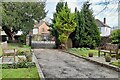
Entrance path to Zion Baptist Chapel, Ponthir
Image: © Robin Drayton
Taken: 21 Feb 2022
0.06 miles
5
Station Road, Ponthir, Torfaen
Viewed across the B4236 Caerleon Road in May 2020. The sign on the right shows that STATION ROAD is HEOL YR ORSAF in Welsh. Station Road formerly led to Ponthir railway station where passenger services ended in 1962.
Image: © Jaggery
Taken: 22 May 2020
0.07 miles
6
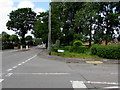
Junction of Caerleon Road and Candwr Park, Ponthir, Torfaen
From the right, the road named Candwr Park joins the B4236 Caerleon Road.
Image: © Jaggery
Taken: 22 May 2020
0.07 miles
7
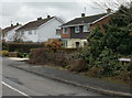
Moyle Grove, Ponthir
Houses on the east side of Moyle Grove, near the corner of Hafod Road.
Image: © Jaggery
Taken: 25 Mar 2010
0.07 miles
8
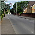
Caerleon Road in Ponthir towards Cwmbran
Looking to the NW along the B4236 Caerleon Road towards Llanfrechfa and Cwmbran.
Image: © Jaggery
Taken: 6 Jul 2019
0.07 miles
9
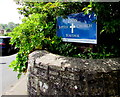
Zion Baptist Church nameboard, Station Road, Ponthir, Torfaen
Located here. https://www.geograph.org.uk/photo/6483928 The board shows EST(ABLISHED) 1803, the year the Baptist cause was established in Ponthir. The church https://www.geograph.org.uk/photo/6483919 dates from 1836.
Image: © Jaggery
Taken: 22 May 2020
0.07 miles
10
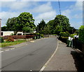
NE along Station Road, Ponthir, Torfaen
Ahead for the B4236 Caerleon Road.
Image: © Jaggery
Taken: 22 May 2020
0.07 miles