IMAGES TAKEN NEAR TO
Walnut Tree Lane, NEWPORT, NP18 1DD
Introduction
This page details the photographs taken nearby to Walnut Tree Lane, NP18 1DD by members of the Geograph project.
The Geograph project started in 2005 with the aim of publishing, organising and preserving representative images for every square kilometre of Great Britain, Ireland and the Isle of Man.

There are currently over 7.5m images from over14,400 individuals and you can help contribute to the project by visiting https://www.geograph.org.uk
Image Map
Images are licensed for reuse under creativecommons.org/licenses/by-sa/2.0
Notes
- Clicking on the map will re-center to the selected point.
- The higher the marker number, the further away the image location is from the centre of the postcode.
Image Listing (42 Images Found)
Images are licensed for reuse under creativecommons.org/licenses/by-sa/2.0
Image
Details
Distance
1
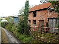
Farm buildings, Llanddewi Fach
The buildings are alongside the lane from Tre-herbert Road to Sor Brook.
Llanddewi Fach is sometimes spelt in the semi-Anglicised form Llanthewy Vach.
Image: © Jaggery
Taken: 27 Sep 2011
0.04 miles
2
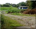
Hilly farmland, Llanddewi Fach
Viewed from a track near the lane from Tre-herbert Road to Sor Brook.
Image: © Jaggery
Taken: 27 Sep 2011
0.05 miles
3
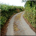
Fallen apples in a lane near Llanddewi Fach
This early autumn view along the lane from Tre-herbert Road to Sor Brook
shows dozens of apples slowing rotting on the lane.
Image: © Jaggery
Taken: 27 Sep 2011
0.06 miles
4
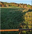
Field in Llanddewi Fach, Monmouthshire
Viewed from this https://www.geograph.org.uk/photo/7024971 gate in November 2021.
Image: © Jaggery
Taken: 21 Nov 2021
0.09 miles
5
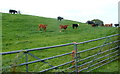
Interested observers in a field alongside the lane from Tre-herbert Road to Sor Brook
Cattle is a suitably gender-neutral word for these bovines in a field.
I don't know whether they are all bulls (unlikely) or young cows (heifers) before their udders have developed.
Image: © Jaggery
Taken: 27 Sep 2011
0.13 miles
6
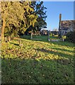
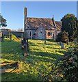
St Davids churchyard, Llanddewi Fach, Monmouthshire
Viewed in November 2021. The former St Davids Church in the background is now in residential use.
Image: © Jaggery
Taken: 21 Nov 2021
0.13 miles
7
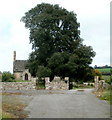
Dominant churchyard tree, Llanddewi Fach
The tree towers over the churchyard of the former church of St David. http://www.geograph.org.uk/photo/3378257
Image: © Jaggery
Taken: 27 Sep 2011
0.14 miles
8
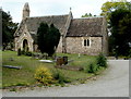
Former St Davids Church, Llanddewi Fach
Now a private residence. Kelly's Directory of Monmouthshire (1901 edition) records:
"The present church of St David, erected in 1857 on the site of the ancient church, is a building of stone, in the Perpendicular style, consisting of chancel, nave, south porch and a western turret
containing 2 bells: there are 80 sittings, all free."
Image: © Jaggery
Taken: 27 Sep 2011
0.14 miles
9
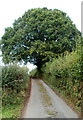
A mighty oak dominates the lane from Tre-herbert Road to Sor Brook
This impressive tree shows up well on satellite images,
from which I estimate its crown to be 25 metres long and
17 metres wide (across the lane).
I don't know if such dimensions are typical for an oak
(or whether there are two oaks side-by-side here).
Image: © Jaggery
Taken: 27 Sep 2011
0.14 miles
10
House formerly a church, Llanddewi Fach, Monmouthshire
Formerly St Davids Church, accessed from Tre-Herbert Road via St Davids Lane. https://www.geograph.org.uk/photo/7024440
Image: © Jaggery
Taken: 21 Nov 2021
0.14 miles