IMAGES TAKEN NEAR TO
Tanhouse Drive, NEWPORT, NP18 1BS
Introduction
This page details the photographs taken nearby to Tanhouse Drive, NP18 1BS by members of the Geograph project.
The Geograph project started in 2005 with the aim of publishing, organising and preserving representative images for every square kilometre of Great Britain, Ireland and the Isle of Man.

There are currently over 7.5m images from over14,400 individuals and you can help contribute to the project by visiting https://www.geograph.org.uk
Image Map
Images are licensed for reuse under creativecommons.org/licenses/by-sa/2.0
Notes
- Clicking on the map will re-center to the selected point.
- The higher the marker number, the further away the image location is from the centre of the postcode.
Image Listing (376 Images Found)
Images are licensed for reuse under creativecommons.org/licenses/by-sa/2.0
Image
Details
Distance
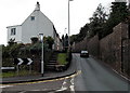
1
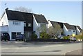
Houses on the north side of Tan House Drive, Caerleon
The style of house contrasts with those on the south side. http://www.geograph.org.uk/photo/1813522
Until the 1960s, this was the site of Tan House Farm.
Image: © Jaggery
Taken: 17 Apr 2010
0.02 miles
2
Houses on the south side of Tan House Drive, Caerleon
The style of house contrasts with those on the north side. http://www.geograph.org.uk/photo/1813516
Until the 1960s, this was the site of Tan House Farm.
Image: © Jaggery
Taken: 17 Apr 2010
0.02 miles
3
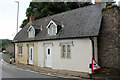
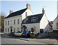
96 and 98 Mill Street, Caerleon
Pair of Grade II Listed early to mid 19th century Tudor Revival cottages. 96 last sold in 2013 was described as a semi-detached one bedroom cottage.
Image: © Jo and Steve Turner
Taken: 24 Jul 2022
0.04 miles
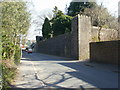
4
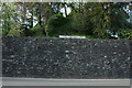
Castle Motte, Caerleon
This is the only available glimpse of the motte in Caerleon as it is a private site. The wall surrounding the site was built in 1840.
Image: © Philip Halling
Taken: 11 Apr 2009
0.06 miles
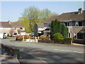
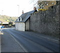
5
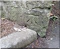
Ordnance Survey Cut Mark
This OS cut mark can be found on the wall at the junction of Mill Street & Cattle Lane. It marks a point 12.229m above mean sea level.
Image: © Adrian Dust
Taken: 17 Jun 2018
0.07 miles
6
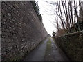
Castle Lane, Caerleon
Viewed from the Castle Street end looking SW towards High Street.
Image: © Jaggery
Taken: 3 Jan 2014
0.07 miles
7
Corner of Castle Street and Castle Mews, Caerleon
The wall on the right was built in 1820 around some of the perimeter of the former Caerleon Castle.
Only the ruins of one 13th century tower remain of the medieval stonework of the castle, built in the Norman period.
Image: © Jaggery
Taken: 3 Jan 2014
0.08 miles
8
Millbrook Cottage and Millbrook House, Caerleon
Located on Mill Street.
Image: © Jaggery
Taken: 17 Apr 2010
0.08 miles
9
Castle-like wall, Caerleon
Viewed from Mill Street.
The wall was built in 1820 around some of the perimeter of the former Caerleon Castle. Only the ruins of one 13th century tower remain of the medieval stonework of the castle, which was built in the Norman period.
Image: © Jaggery
Taken: 17 Apr 2010
0.08 miles
10
Listed cottages, Caerleon
Two Grade II listed cottages at 96 and 98 Mill Street, opposite Tan House Drive.
The cottages are at the southeast end of Mill Street : beyond is Castle Street.
Image: © Jaggery
Taken: 17 Apr 2010
0.09 miles