IMAGES TAKEN NEAR TO
Mill Street, NEWPORT, NP18 1BL
Introduction
This page details the photographs taken nearby to Mill Street, NP18 1BL by members of the Geograph project.
The Geograph project started in 2005 with the aim of publishing, organising and preserving representative images for every square kilometre of Great Britain, Ireland and the Isle of Man.

There are currently over 7.5m images from over14,400 individuals and you can help contribute to the project by visiting https://www.geograph.org.uk
Image Map
Images are licensed for reuse under creativecommons.org/licenses/by-sa/2.0
Notes
- Clicking on the map will re-center to the selected point.
- The higher the marker number, the further away the image location is from the centre of the postcode.
Image Listing (529 Images Found)
Images are licensed for reuse under creativecommons.org/licenses/by-sa/2.0
Image
Details
Distance
1
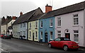
Pastel shades in Mill Street, Caerleon
Mill Street houses viewed from the corner of Cambria Close.
Image: © Jaggery
Taken: 3 Jan 2014
0.01 miles
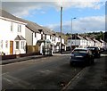
2
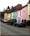
Colourful houses, Mill Street, Caerleon
Alongside the B4236 here named Mill Street.
Image: © Jaggery
Taken: 31 Dec 2018
0.02 miles
3
Mill Street houses, Caerleon
Viewed from the Castle Street end looking towards the Cambria Close junction.
Image: © Jaggery
Taken: 3 Jan 2014
0.02 miles
4
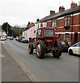
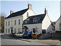
Red tractor in Mill Street, Caerleon
The Massey Ferguson tractor dates from 1981.
Image: © Jaggery
Taken: 31 Dec 2018
0.04 miles
5
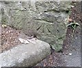
Ordnance Survey Cut Mark
This OS cut mark can be found on the wall at the junction of Mill Street & Cattle Lane. It marks a point 12.229m above mean sea level.
Image: © Adrian Dust
Taken: 17 Jun 2018
0.04 miles
6
Castle Lane, Caerleon
Viewed from the Castle Street end looking SW towards High Street.
Image: © Jaggery
Taken: 3 Jan 2014
0.04 miles
7
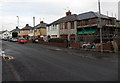
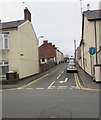
Mill Street bus stop and shelter, Caerleon
This stop alongside Mill Street is for buses to Newport city centre.
The B4236 Mill Street is part of the one-way system through the centre of Caerleon.
Image: © Jaggery
Taken: 1 Nov 2018
0.06 miles
8
Arthur Street, Caerleon
Dead-end street viewed across Mill Street.
Image: © Jaggery
Taken: 31 Dec 2018
0.06 miles
9
Millbrook Cottage and Millbrook House, Caerleon
Located on Mill Street.
Image: © Jaggery
Taken: 17 Apr 2010
0.06 miles
10
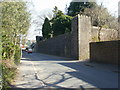
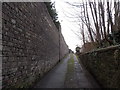
Castle-like wall, Caerleon
Viewed from Mill Street.
The wall was built in 1820 around some of the perimeter of the former Caerleon Castle. Only the ruins of one 13th century tower remain of the medieval stonework of the castle, which was built in the Norman period.
Image: © Jaggery
Taken: 17 Apr 2010
0.06 miles