IMAGES TAKEN NEAR TO
Norman Street, NEWPORT, NP18 1BB
Introduction
This page details the photographs taken nearby to Norman Street, NP18 1BB by members of the Geograph project.
The Geograph project started in 2005 with the aim of publishing, organising and preserving representative images for every square kilometre of Great Britain, Ireland and the Isle of Man.

There are currently over 7.5m images from over14,400 individuals and you can help contribute to the project by visiting https://www.geograph.org.uk
Image Map
Images are licensed for reuse under creativecommons.org/licenses/by-sa/2.0
Notes
- Clicking on the map will re-center to the selected point.
- The higher the marker number, the further away the image location is from the centre of the postcode.
Image Listing (635 Images Found)
Images are licensed for reuse under creativecommons.org/licenses/by-sa/2.0
Image
Details
Distance
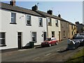
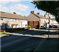
1
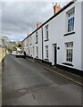
Row of houses, Norman Street, Caerleon
Looking past Norman Terrace towards Mill Street.
Behind the camera for Church Street.
Image: © Jaggery
Taken: 17 Mar 2022
0.01 miles
2
Norman Terrace, Caerleon
Row of houses alongside Norman Street.
The Norman Terrace name sign is on the left.
Image: © Jaggery
Taken: 17 Mar 2022
0.01 miles
3
One-way sign, Norman Street, Caerleon
Norman Street is one of several one-way streets in the centre of Caerleon in 2022.
Image: © Jaggery
Taken: 17 Mar 2022
0.01 miles
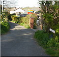
4
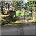
Norman Street entrance to Orchard House, Caerleon
In March 2022 a notice on an entrance gate shows
"ORCHARD HOUSE
NATIONAL AUTISTIC SOCIETY NEWPORT
NO UNAUTHORISED ACCESS"
"If you are delivering a parcel or have an appointment please telephone" (the number shown) "for assistance. Other deliveries please use Mill Street entrance" (directions given).
Image: © Jaggery
Taken: 17 Mar 2022
0.01 miles
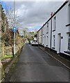
5
Norman Street, Caerleon
Houses on the east side of the street, viewed from the corner of Mill Street.
The far end of Norman Street connects with Church Street.
Image: © Jaggery
Taken: 17 Apr 2010
0.01 miles
6
Tram Lane, Caerleon
Viewed from Mill Street.
Trams (or tram roads or tram lanes) were roads with wooden, stone, or metal wheel-tracks, originally in or from a coalmine, later used more widely. Once common in south-east Wales, nowadays the street name is often the only remaining evidence of a tram.
Another former tram road is nearby. http://www.geograph.org.uk/photo/1634455
Image: © Jaggery
Taken: 17 Apr 2010
0.01 miles
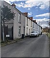
7
Houses, Mill Street, Caerleon
Houses on the west side of the central section of Mill Street.
Mill Street is part of the one-way system through the narrow streets of central Caerleon.
Image: © Jaggery
Taken: 17 Apr 2010
0.01 miles
8
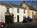
Sarum House, Caerleon
Bed & breakfast accommodation at 13A Mill Street.
Image: © Jaggery
Taken: 17 Apr 2010
0.01 miles
9
Caerleon : Mill Street houses
Houses on the NE side of the street.
Image: © Jaggery
Taken: 30 Aug 2010
0.01 miles
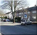
10
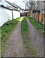
Path between houses, Caerleon
Viewed from Norman Street.
Image: © Jaggery
Taken: 17 Mar 2022
0.02 miles