IMAGES TAKEN NEAR TO
Crown Close, NEWPORT, NP18 1AT
Introduction
This page details the photographs taken nearby to Crown Close, NP18 1AT by members of the Geograph project.
The Geograph project started in 2005 with the aim of publishing, organising and preserving representative images for every square kilometre of Great Britain, Ireland and the Isle of Man.

There are currently over 7.5m images from over14,400 individuals and you can help contribute to the project by visiting https://www.geograph.org.uk
Image Map
Images are licensed for reuse under creativecommons.org/licenses/by-sa/2.0
Notes
- Clicking on the map will re-center to the selected point.
- The higher the marker number, the further away the image location is from the centre of the postcode.
Image Listing (618 Images Found)
Images are licensed for reuse under creativecommons.org/licenses/by-sa/2.0
Image
Details
Distance
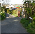
1
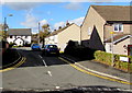
Roman Gates leading to Crown Close, Caerleon
From Backhall Street, the road named Roman Gates leads to Crown Close.
Image: © Jaggery
Taken: 1 Nov 2018
0.01 miles
2
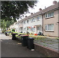
Wheelie bins and houses, Mill Street, Caerleon
On the south side of Mill Street near the Tram Road junction.
Image: © Jaggery
Taken: 26 Jul 2019
0.02 miles
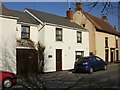
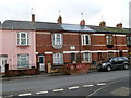
3
Mill Street houses, Caerleon
Houses alongside the B4236 Mill Street viewed from the corner of Backhall Street.
Poachers Cottage is on the right.
Image: © Jaggery
Taken: 1 Nov 2018
0.03 miles
4
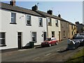
Norman Street, Caerleon
Houses on the east side of the street, viewed from the corner of Mill Street.
The far end of Norman Street connects with Church Street.
Image: © Jaggery
Taken: 17 Apr 2010
0.03 miles
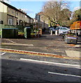
5
Tram Lane, Caerleon
Viewed from Mill Street.
Trams (or tram roads or tram lanes) were roads with wooden, stone, or metal wheel-tracks, originally in or from a coalmine, later used more widely. Once common in south-east Wales, nowadays the street name is often the only remaining evidence of a tram.
Another former tram road is nearby. http://www.geograph.org.uk/photo/1634455
Image: © Jaggery
Taken: 17 Apr 2010
0.03 miles
6
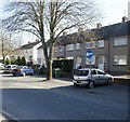
Houses, Mill Street, Caerleon
Houses on the west side of the central section of Mill Street.
Mill Street is part of the one-way system through the narrow streets of central Caerleon.
Image: © Jaggery
Taken: 17 Apr 2010
0.03 miles
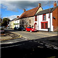
7
Sarum House, Caerleon
Bed & breakfast accommodation at 13A Mill Street.
Image: © Jaggery
Taken: 17 Apr 2010
0.03 miles
8
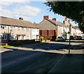
Caerleon : Mill Street houses
Houses on the NE side of the street.
Image: © Jaggery
Taken: 30 Aug 2010
0.03 miles
9
Caerleon : former Cecil Terrace houses now part of Mill Street
Viewed from the corner of Cambria Close. A stone inscription on the house behind the skip shows Cecil Terrace 1885. Cecil Terrace was formerly the address of a group of 14 houses either side of the Arthur Street junction. Cecil Terrace no longer exists as a named street. It is listed in a 1955 directory of Caerleon, so it must have become part of Mill Street (and its houses renumbered) some time later.
Image: © Jaggery
Taken: 22 Dec 2011
0.03 miles
10
Two telecoms cabinets on a Caerleon corner
Two dark green cabinets on the corner of Backhall Street and Mill Street.
Image: © Jaggery
Taken: 1 Nov 2018
0.03 miles