IMAGES TAKEN NEAR TO
Carlton Terrace, NEWPORT, NP18 1AD
Introduction
This page details the photographs taken nearby to Carlton Terrace, NP18 1AD by members of the Geograph project.
The Geograph project started in 2005 with the aim of publishing, organising and preserving representative images for every square kilometre of Great Britain, Ireland and the Isle of Man.

There are currently over 7.5m images from over14,400 individuals and you can help contribute to the project by visiting https://www.geograph.org.uk
Image Map
Images are licensed for reuse under creativecommons.org/licenses/by-sa/2.0
Notes
- Clicking on the map will re-center to the selected point.
- The higher the marker number, the further away the image location is from the centre of the postcode.
Image Listing (525 Images Found)
Images are licensed for reuse under creativecommons.org/licenses/by-sa/2.0
Image
Details
Distance
1
High Street, Caerleon at The Hanbury Arms
Image: © Colin Pyle
Taken: 2 Jan 2015
0.01 miles
2
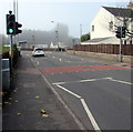
Pelican crossing, High Street, Caerleon
Across the B4236 High Street. Chambers Dictionary states that pelican
in this context is adapted from "pedestrian light controlled crossing".
Image: © Jaggery
Taken: 19 Oct 2018
0.01 miles
3
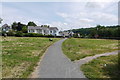
Houses in Whitehart Lane
This short residential street is just behind the High St close to the River Usk near the main bridge across the river.
Image: © Nigel Mykura
Taken: 3 Jul 2015
0.01 miles
4
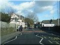
Many-armed signpost at the edge of Carlton Terrace, Caerleon
Viewed across the B4236. Locations shown on the brown arms include Roman Barracks, Roman Amphitheatre, Fortress Walls Footpath and the Tourist Information Centre. The white arrow on the blue sign points left for Newport (4 miles) along National Cycle Network route 88.
Image: © Jaggery
Taken: 3 Jan 2014
0.02 miles
5
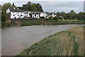
The Hanbury Arms and River Usk at Caerleon
Image: © Roger Davies
Taken: 10 May 2014
0.02 miles
6
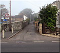
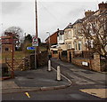
NW along Carlton Terrace, Caerleon
From High Street, Carlton Terrace leads to White Hart Lane.
A sign on the left indicates no motor vehicles except for access.
Image: © Jaggery
Taken: 19 Oct 2018
0.02 miles
7
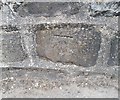
Ordnance Survey Cut Mark
This OS cut mark can be found on the wall NW side of the road. It marks a point 11.928m above mean sea level.
Image: © Adrian Dust
Taken: 17 Jun 2018
0.02 miles
8
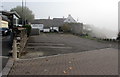
Hanbury Arms car park, Caerleon
Pub car park between High Street and the River Usk where thick fog lingers
on an October morning in 2018. The fog cleared soon after this photo was taken.
Image: © Jaggery
Taken: 19 Oct 2018
0.02 miles
9
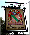
Hanbury Arms name sign, Caerleon
On the right here. https://www.geograph.org.uk/photo/5945538
Image: © Jaggery
Taken: 19 Oct 2018
0.03 miles
10
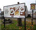
Daytime Set Menu information outside the Hanbury Arms, Caerleon
On display alongside High Street on October 19th 2018.
The Hanbury Arms name sign https://www.geograph.org.uk/photo/5945539 is on the right.
Image: © Jaggery
Taken: 19 Oct 2018
0.03 miles